14. september 2014 12:30 - from the Scientific Advisory Board
Scientists from the Icelandic Met Office and the Institute of Earth Sciences and representatives of the Civil Protection in Iceland attend the meetings of the Scientific Advisory Board of the Icelandic Civil Protection. A representative from The Environment Agency of Iceland was also present.
Conclusions of the Scientific Advisory Board of the Icelandic Civil Protection:
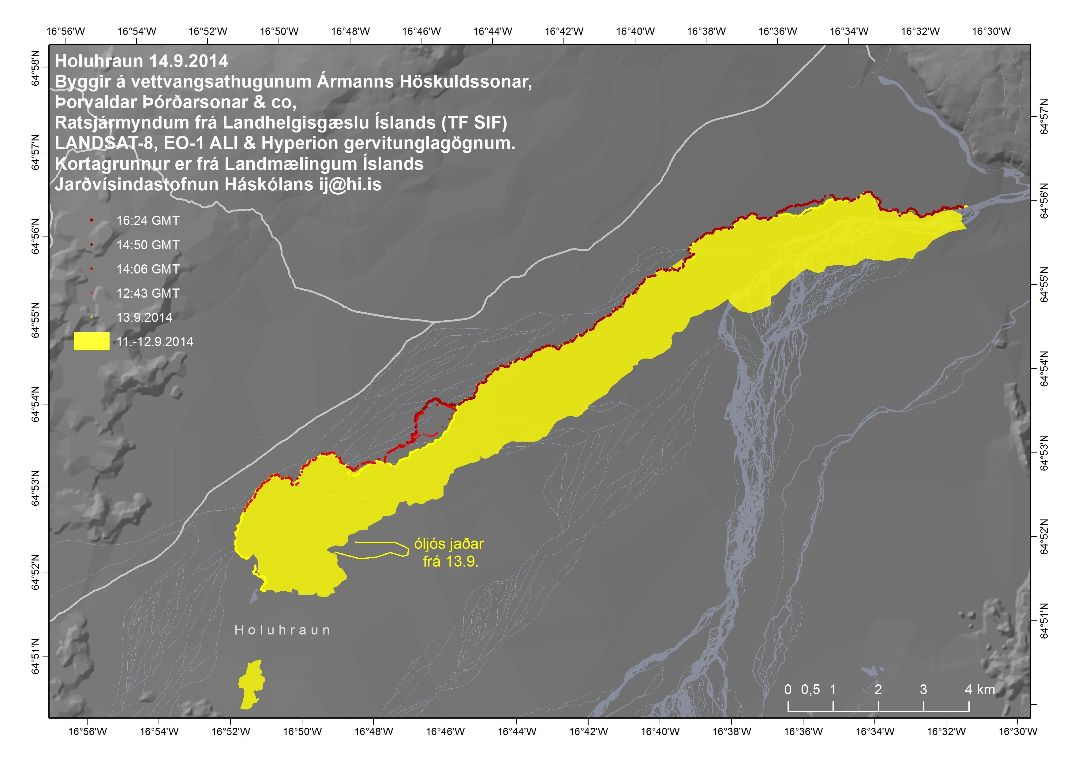
The eruptive activity at Holuhraun continues at similar intensity. The lava flows at slower rates than it did yesterday. The lava is now spreading more to the sides and there is less visible activity is in the eruptive craters.
The subsidence of the Bárðarbunga caldera continues and is now up to 23 meters.
Scientists flying over the area saw new tongues of lava breaking out from the main lava stream towards the east and west. The largest one of these lava tongues stretches towards the east and had become 300 m wide and 2 km long at 18:00 yesterday. An eruption cloud reaches 4 km in height but lowers with distance from the eruption site.
Seismic activity is similar to what it has been in the past days but earthquakes are starting to go down in numbers and magnitude. Over 60 earthquakes have been detected since midnight. Most of them have been by Bárðarbunga and the dyke under Dyngjujökull. The biggest earthquake, of magnitude 4.0, was detected today at around 07:00 in the south of Bárðarbunga. Three other earthquakes of 3.0 in magnitude or more have been detected today.
GPS monitoring shows continuing subsidence in Bárðarbunga and insignificant crustal movements north of Vatnajökull around the dyke.
Air quality in urban areas in the East of Iceland:
High air pollution was detected yesterday in Egilsstaðir and Reyðarfjörður. Forecasts indicate that the gas cloud will blow towards the north in the next 24 hours. High concentrations of sulphuric gases can be expected in Mývatnssveit, Kelduhverfi, Tjörnes, Húsavík, Aðaldalur and Reykjahverfi.
Instructions:
- People who feel discomfort are advised to stay indoors, close their windows, turn up the heat and turn off air conditioning. Use periods of good air quality to ventilate the house. Measurements of air quality can be found on the webpage www.loftgaedi.is The Meteorological Office issues forecast on its web-page and warnings if conditions change to the worse.
- Instructions from the office of the Chief Epidemiologist and The Environment Agency can be found on their web-sites www.ust.is and www.landlaeknir.is
- The Icelandic Met Office will read forecasts for sulphuric gases along with weather news on the national radio and TV.
- The Environment Agency is working on getting more measuring equipment to better monitor the gases coming from the volcanic eruption.
- Information and any questions on air pollution can be sent to The Environment Agency through the email gos@ust.is. The Environment Agency is especially looking for information from people who have been in contact with high concentrations of gas; where they were, at what time it happened, how the gas cloud looked (colour and thickness of the cloud) and how they were affected by it. In the near future, there will be a page on the IMO's webpage for this type of information.
- Gas emissions at the eruption site remain high. As local gas concentrations at the site can be life threatening, people at the eruption site should wear gas masks and gas meters. At the eruption site, local wind anomalies can occur due to thermal convection from the hot lava. This makes the conditions on site extremely dangerous as winds can change suddenly and unpredictably. Scientists in the field have gas meters for their security.
- Subsidence of the Bárðarbunga caldera stops and the eruption on Holuhraun declines gradually.
- Large-scale subsidence of the caldera occurs, prolonging or strengthening the eruption on Holuhraun. In this situation, it is likely that the eruptive fissure would lengthen southwards under Dyngjujökull, resulting in a jökulhlaup and an ash-producing eruption. It is also possible that eruptive fissures could develop in another location under the glacier.
- Large-scale subsidence of the caldera occurs, causing an eruption at the edge of the caldera. Such an eruption would melt large quantities of ice, leading to a major jökulhlaup, accompanied by ashfall.
From the Icelandic Met Office: The Aviation Colour Code for Bárðarbunga remains at ‘orange' and the code for Askja is ‘green'.
source

No comments :
Post a Comment