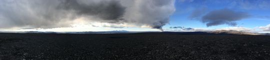
Panoramic view towards the eruptive site in Holuhraun 3rd September 2014. Photo: Richard Yeo.
13 September 2014 19:00 - from geoscientist on duty
Comparatively quiet at the eruptive front, 85 earthquakes have been detected. Most of them, 38, near the northern end of the intrusive dike but 22 in Bárðarbunga, 19 around Herðubreið and Herðubreiðartögl and 6 elsewhere in the country.The largest earthquake of the day occurred at 07:58 this morning in the nortern part of Bárðarbunga, M4.9, and it was accompanied by ca. 25 cm lowering of the caldera according to the newly installed GPS meter there. In the afternoon, two earthquakes close to M3.5 occurred, both in Bárðarbunga. Other earthquakes have been smaller. According to scientists in the field the activity has diminished and the only crater which is active, is the one named Baugur.
13 September 2014 11:30 - from the Scientific Advisory Board
Scientists from the Icelandic Met Office and the Institute of Earth Sciences and representatives of the Civil Protection in Iceland attend the meetings of the Scientific Advisory Board of the Icelandic Civil Protection. Representative from The Environment Agency of Iceland and the Chief Epidemiologist and the Directorate of Health, were also present.
Conclusions of the Scientific Advisory Board of the Icelandic Civil Protection:
- The eruptive activity at Holuhraun and the the subsidence of the Bárðarbunga caldera floor continues at similar intensity.
- The subsidence of the Bárðarbunga caldera and seismic activity continues the same as the last few days. The GPS station on top of Bárðarbunga shows a subsidence of the caldera around half a meter over the last 24 hours.
- The volcanic eruption in Holuhraun is still ongoing with similar strength as last few days. Lava flows at similar rates as yesterday towards East into Jökulsá á Fjöllum.
- The lava filed was measured yesterday afternoon to be 24,5 square kilometres.
- Accumulated volume of the lava is now estimated to be at least 200 million cubic meters.
- Gas cloud from the eruption drifts to the east. High level of SO2, sulphur dioxide, was measured at Reyðarfjörður last night around 10:00 o'clock. The highest value measured were just under 4000 micrograms per cubic meter. These are the highest values measured in Iceland. High level, 685 micrograms per cubic meter, was also measured in Egilsstaðir.
- Warning was sent via the GSM system to all mobile phones in Fjarðarbyggð.
- Air quality in urban areas in the East of Iceland:
-
- Forecasts indicate that high concentrations of sulphuric gases may be expected in the northern part of the Eastern fjords, Fljótsdalur, Hérað, Jökuldalur, and on Langanes. Forecast indicates that concentration may become higher later today. The Environment Agency will set up new monitoring stations in Akureyri and in South Iceland. Geographical conditions must be considered when estimating air quality.
- Instructions:
-
- People who feel discomfort are advised to stay indoors, close the windows, turn up the heat and turn off air conditioning. Use periods of good air quality to ventilate the house. Measurements of air quality can be found on a map from the Environment Agency. The Icelandic Met Office issues text forecasts and warnings in header if conditions change to the worse.
- Some advise from The Environment Agency can be found on their web-site.
- The Icelandic Met Office will read forecasts for sulphuric gases along with weather news on the national radio and TV.
- The Environment Agency is working on getting more measuring equipment to better monitor the gases coming from the volcanic eruption.
- Air quality at the eruption site:
-
- Gas emissions at the eruption site remain high. As local gas concentrations at the site can be life threatening, people at the eruption site should wear gas masks and gas meters. At the eruption site, local wind anomalies can occur due to thermal convection from the hot lava. This makes the conditions on site extremely dangerous as winds can change suddenly and unpredictably. Scientists in the field carry gas meters for their security.
- Degassing from the volcanic eruption is now estimated to be up to 750 kg/sec.
- Three scenarios are considered most likely:
-
- Subsidence of the Bárðarbunga caldera stops and the eruption on Holuhraun declines gradually.
- Large-scale subsidence of the caldera occurs, prolonging or strengthening the eruption on Holuhraun. In this situation, it is likely that the eruptive fissure would lengthen southwards under Dyngjujökull, resulting in a jökulhlaup and an ash-producing eruption. It is also possible that eruptive fissures could develop in another location under the glacier.
- Large-scale subsidence of the caldera occurs, causing an eruption at the edge of the caldera. Such an eruption would melt large quantities of ice, leading to a major jökulhlaup, accompanied by ashfall.
- Other scenarios cannot be excluded.
From the Icelandic Met Office:
The Aviation Colour Code for Bárðarbunga remains at ‘orange'.13 September 2014 06:50 - from geoscientist on duty
Since midnight, around 20 earthquakes have been recorded in the north-west region of Vatnajökull. Earthquake locations are similar to recent days: in Bárðarbunga, in the dyke intrusion near to the edge of Dyngjujökull, and occasionally at Herðubreiðartögl. See maps (second image) and weekly overview. At 23:59 (12 Sept.), an earthquake of magnitude 4,7 occurred on the rim of the Bárðarbunga caldera. Web camera views of the eruption site during the night showed volcanic activity at similar levels to yesterday.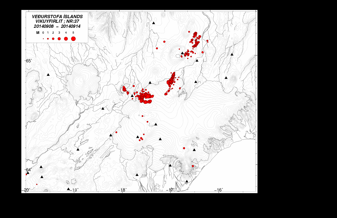
via the Icelandic Met Office

No comments :
Post a Comment