Fissure Eruption Update
Experts at Discover The World and Ari Trausti Guðmundsson
19/10/2014
The lava outpouring from the short fissure at Holuhraun has now
remained steady for weeks. Three interconnected vents (300-400 m long)
are what remains of the original 1.9-km-long, once active fissure. The
height of the crater hill around the vents exceeds 100 m, taking the
form of a lava shield (also known as a shield volcano) - see the image
from the Geoscience institute by geoscientist Morten Riishuus. The big
regional dyke is still going strong and the eruption could remain active
for many years or die down within a few weeks or months. Further
breaching of the surface along the dyke leading to a subglacial eruption
in the Dyngjujökull outlet glacier is still possible.
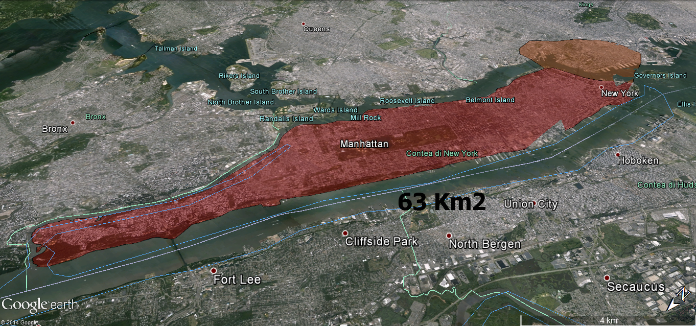
The lava flow now has an area of roughly 60km² and a volume of
approximately 800 million cubic metres (0.8 cu. km). The Hekla lava flow
is somewhat similar in size but was generated in 13 months. Therefore,
the highlands will soon become the largest lava flow occurring within
such a short interval in Iceland - since the late 18th century. New
trace elements and isotope analysis are said to indicate a magma source
at a depth of at least 15 km.
The included map is from the Geoscience Institute and the Coast Guard (October 17th).
The Bárðarbunga central volcano continues to shudder, with dozens of
earthquakes every day. On October 18th, two earthquakes were recorded
with a magnitude 4.7 and 5.0, with a further two on the 19th with a
magnitude of 5.2 and 4.5. Currently, the depression in the caldera ice
dome is over 35 m deep. The main earthquake location is at the northern
rim of the caldera or at the volcano flank in the north. GPS-readings
over a period of a few days show both dilation and/or doming of the
volcano.
Reverse faulting has been detected from some earthquakes.
Another earthquake location is at the south-eastern rim. Practically no
earthquakes originate in the caldera floor. With time, a simple model of
caldera floor subsidence and a direct link between a Bárðarbunga magma
chamber and the big dyke seems more and more unlikely.
I have stressed before, as have prof. Águst Guðmundsson (Royal
Holloway – University of London) and prof. Þorvaldur Þórðarson
(University of Iceland) in talks and in an article (in the Bulletin of
Volcanology), that a large magma reservoir, is the possible site of the
magma influx into the dyke.
Independently of this, the roots and the
non-verified (but naturally alleged), shallow magma chamber remains
beneath the caldera, a theory consistent with chemical signals in the
magma. The magma from a deeper reservoir is probably being injected into
the volcano, even as ring dykes. It remains to be seen if this
hypothesis is correct but many indications are present.
There is no
way to predict what will happen at Bárðarbunga; small or large eruptions
may occur, and similar tectonic movements or a sudden caldera collapse
could become the result of the processes in the volcano.
The many scenarios presented by the Civil Protection and its Scientific council are still valid.
The
nearby Tungnafellsjökull central volcano (with a caldera), west of
Bárðarbunga, has been the site of over 150 earthquakes (with the
majority of them with magnitude less than 3.0). Most of them have loci
at shallow depth but some originate much deeper, at up to 20 km plus.
This probably indicates an influx of magma but the GPS-readings do not
support that, so far. Magma intrusions in a volcano do not automatically
lead to eruptions.
It is interesting to note that the Kverkfjöll central volcano (with
two calderas), the next neighbour of Bárðarbunga in the east is showing
very little tectonic activity. Only a few dozen quakes have originated
there and the same story can be said about the very active Grímsvötn
central volcano southeast of Bárðarbunga. It is, at any rate, important
to follow the development of all nearby volcanoes with care.
More elaborate seismic and GPS monitoring would help in revealing the
processes at hand below the earth´s surface in this very active part of
Iceland.
Compiled by: Geoscience Institute of the University of Iceland/Coast Guard
Map base: The Geodetic Survey.
Photo: Morten Riishuus, Geoscience Institue
Dates: 28th of Sept. and 15th of Oct.
source