Friday, October 26, 2012

Salton Sea Volcano Mystery Solved

Moonset at Rock Hill, one of five volcanoes that comprise the Salton Buttes. The buttes last erupted between 940 and 0 B.C., not 30,000 years ago, as previously thought, a new study finds.
CREDIT: U.S. Fish and Wildlife Service
Earthquake swarms and a region-wide rotten egg smell recently reminded Southern California residents they live next to an active volcano field, tiny though it may be.
At the time, scientists said the phenomena did not reflect changes in the magma chamber below the Salton Sea. But now, researchers may need to revise estimates of the potential hazard posed by the Salton Buttes — five volcanoes at the lake's southern tip.

The buttes last erupted between 940 and 0 B.C., not 30,000 years ago, as previously thought, a new study detailed online Oct. 15 in the journal Geology reports. The new age — which makes these some of California's youngest volcanoes — pushes the volcanic quintuplets into active status. The California Volcano Observatory, launched in February by the U.S. Geological Survey (USGS), already lists the area as a high threat for future blasts.

"The USGS is starting to monitor all potentially active volcanoes in California, which includes the Salton Buttes," said study author Axel Schmitt, a geochronologist at the University of California, Los Angeles. "With our results, I think this will further enhance the need to look into the system," Schmitt told OurAmazingPlanet.

Schmitt and his colleagues dated zircon crystals in the hardened lava of the buttes with a relatively new technique, a "helium clock" that starts ticking once the minerals begin cooling at the surface.

Resolving the Obsidian Butte riddle

The revised age solves a long-standing archeological conundrum, said Steve Shackley, emeritus professor of anthropology at the University of California, Berkeley. Artifacts created from one of the five buttes, Obsidian Butte, first appear in Native American villages around 510 B.C. to 640 B.C. The Kumeyaay people, whose territory ranged from the coast to the Coso Mountains, crafted projectiles from Obsidian Butte glass, he said. "The men produced some of the best in the world," Shackley told OurAmazingPlanet.

Projectile point made from Obsidian Butte obsidian, collected west of Palomar Mountain in northern San Diego County, and attributed to the Luiseño cultural territory.
CREDIT: Janet C. Harvey/Axel Schmitt

 However, for decades, researchers thought Obsidian Butte erupted thousands of years earlier. To explain why no one collected the valuable obsidian, archeologists hypothesized that Obsidian Butte was submerged under ancient Lake Cahuilla, the precursor to today's Salton Sea. But geologists had long proved that Lake Cahuilla was ephemeral, flooding and emptying over and over again, so the explanation was always problematic.

"If this dating method is correct, then the Obsidian Butte material wasn't even available, and that makes more sense archaeologically," Shackley said.

Rifting brings rising magma

In fact, that Obsidian Butte rises above the Salton Sea is what first attracted Schmitt's attention. A 30,000-year-old butte should have been buried by a combination of sediment and subsidence by now, he said. "It had to be very young," Schmitt said.

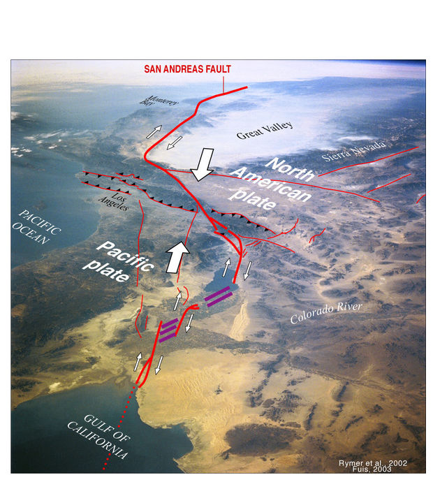
The buttes exist because California is tearing apart, forming new oceanic crust as magma wells up from below. The sinking Salton Trough is the landward extension of the Gulf of California, and marks the boundary between the Pacific and North America tectonic plates.

The lava source for the volcanoes is a magma chamber beneath the Salton Sea, which also heats water for a nearby geothermal plant. Decay of uranium isotopes in zircon crystals show magma built up underneath the volcanoes for thousands of years before the latest eruption, the study shows.

If another eruption occurs at the Salton Buttes, it will likely mimic past breakouts, Schmitt said. The volcanoes are made of sticky, slow-moving rhyolite lava. At Obsidian Butte, the lava cooled so quickly it turned into glass. However, pumice and ash found nearby means past breakouts started with a bang.

Schmitt said he hopes to study the area in more detail to better understand the most recent eruption. "The amounts of magma involved are relatively small and the impacts of an explosive eruption, meaning an ash cloud, would most likely be very local," he said. "We don't know very well how far any ash would have been dispersed, and that's something I would like to follow up on in the research."

Researching future hazards

The National Science Foundation's EarthScope project funds an extensive seismic imaging project in the Salton Sea that may soon reveal more information about what's happening deep underground.
"We'll be looking with great interest to see what we can tell from the Salton Seismic Imaging Project," said Joann Stock, a Caltech professor and an expert on the region's volcanic hazards who was not involved in the new study.

"I think [Schmitt's study] is a great contribution," she said. "It's an area where we should be concerned. We know that there's a lot of hot stuff down there," she told OurAmazingPlanet.
In August, an earthquake swarm shook the nearby town of Brawley. The USGS attributed the temblors to faults in the Brawley Seismic Zone. In September, a sulfurous stench emanated from the Salton Sea and wafted across the Inland Empire. The odor was tentatively linked to a fish die-off, but could also have been caused by volcanic gases, Stock said.

source

Wednesday, October 17, 2012

The Salton Sea Volcanics Part I


Recently, a small taped interview appeared on a San Diego news program that sparked some major interest in many. A geologist shot some footage from a chopper that hovered above the southern rim of the Salton Sea that clearly shows a pit of muddy water roiling like a witch's cauldron. The newscaster spoke of volcanic gases escaping to the surface (probably CO2 and/or H2SO4). This geologist stated that this area could be the setting for volcanic activity and that the USGS is keen on that fact. 

Since the time I bought my first real computer in 1998, and the following year as a geology major at Cal State Fullerton, I have known of the Salton Sea volcanoes. Every map of active US volcanoes that the USGS posts online displays the Salton Sea area as an active volcanic threat. And yet, how many people know or care about anything less than the size of Yellowstone or Rainier or Long Valley? Granted a number of factors would have to play into an eruptive episode for such a thing to be disastrous to the beach side meccas of Southern California; chances are that the Coachella and Imperial Valleys would be more imperiled than anywhere.

Inland Southern California is seductive-so much more than its beach front counterparts. As a recent grad in biology, with each trip past the southern mountain ranges I felt my grip lessen on the herpetological aspects of the desert and grasp more firmly on the stories within the strata of rocks. Never mind the close encounters with killer bees, sidewinders, and heat strokes; I had to be there every day off from work and school. But one area became an obsession: the Salton Sea and its inherent volcanoes. I would like to share that obsession with you of this primordial arena that holds so much mystery, more beauty than any work of art, and geological wonders beyond the imagination. 

But first, let's take a little earth history lesson on how this region was formed. Between 150-90 million years ago, the Peninsular Ranges, west of the Salton Sea, were formed from the same areal process that created the South American Andes, the Central American Cordillera, and the Sierra Nevadas: subduction. The Farallon Plate subducted beneath California and hot magma rose from that juncture to cool slowly into large plutons that became the Peninsular Ranges. Then about 30 million years ago, the North American plate overrode the Farallon Plate (aka the East Pacific Rise) and stopped the subduction of the Farallon. There are a few places where the remnants of that enormous plate still subduct, but for our purposes, we will focus only on what affects Southern California. The energy between the East Pacific Rise and the Pacific Plate was transformed (yes, I know, but it's a good pun) along a lateral fracture of the now buried East Pacific Rise and thus created the San Andreas Fault. 


However, do not discount the affect the still, very active East Pacific Rise has on Southern California. The EPR runs between Baja California and Mexico, separating the two and thereby causing a drop in the land where the Salton Sea lies. Molten lava rises along the break of the rise, causing older lava to be replaced by newer and spreading the older farther and farther from the rise itself. As stated, this spreading, conveyor belt of newly formed oceanic crust widens and thins the crust of the Imperial and Coachella Valleys. 
If you travel from Riverside, east on the 10, you'll soon come to the city of Banning in the San Gorgonio Pass. Banning is a small town that sits on the point of the "V" shaped gräben that comprises the previously mentioned counties. Traveling further east through Cabazon and into the heart of Imperial Valley, the elevation drops from 7oo' to below sea level in the city of Indio. This is the obvious change the East Pacific Rise has had on the suroundings, but there is an even more exciting transformation on the landscape: volcanoes.

Thanks to all that widening and thinning of the crust, magma can more easily find an avenue to the surface. There are five volcanoes or more precisely, five rhyolite domes at the south end of the Salton Sea: Rock Hill, Mullet Island, obsidian Butte, Red Island (Red Island has two domes). For the technical information, I turn to C. Dan Miller's thorough report (1989, Potential Hazards from Future Volcanic Eruptions in California: USGS Bulletin 1847) on the area; here are the specs: 

The Salton Buttes rhyolite center:
  • Most recent eruption: Silicic pyroclastic and extrusive eruptions at four vents approximately 16,000 years ago (Potassium-Argon dating);
  • Five silicic domes erupted;
  • At least one silicic lava flow associated with rhyolite dome;
  • Probable small-volume pyroclastic eruptions with tephra associated with dome emplacement at several vents;
  • No recognized debris avalanches or debris flows;
  • Most probably future potential hazard: Explosive and extrusive rhyolitic eruptions; phreatic and phreato-magmatic eruptions.
Although the youngest eruptions in this area are not known to have produced pyroclastic flows and surges, the compositions of lavas of past eruptions and the association of vents with ground water and the Salton Sea suggest that pyroclastic flows and surges and explosive eruptions could occur in the future. Such events commonly are destructive out to distances of at least 10 kilometers (6 miles) from an active vent.
 ... and from:  Robinson, Elders, and Muffler, 1976, Quaternary volcanism in the Salton Sea geothermal field, Imperial Valley, California: GSA Bulletin 87, p.347-360, March 1976 
 
The Salton Sea geothermal field lies in the Salton Trough, the landward extension of the Gulf of California, an area of active crustal spreading. The Salton Buttes volcanoes lie within the Salton Sea geothermal field where temperatures measured in wells drilled for geothermal brines range up to 360 degrees C at depths of 1,500 to 2,500 meters (Helgeson, 1968). The wells produce a hot brine containing up to 160,000 ppm of dissolved solids, chiefly Cl, Na, K, Ca, and Fe (White, 1968). Under the influence of this hot saline brine, the sediments of the Salton Trough are being transformed into metamorphic rocks of the greenschist facies (Muffler and White, 1969). 
 
From this information alone, one can see that even a phreato-magmatic eruption, an eruption that occurs when hot magma encounters saltwater, shouldn't be devastating to areas such as San Diego or Los Angeles. In short, lots of drama without a major impact other than on those living within the Brawley seismic zone, a large agricultural area south of the Salton Sea. The wind generally blows from the NW due to constriction via canyon walls; the ventifacts (rocks shaped by the wind) tell us that the wind has been blowing from this direction for many, many years. Also, west of the Salton, there is a field of Barchan Sand Dunes that attest to the strength of a wind blowing from one general direction.

South and East of the Salton Sea, one can find along dirt back roads, mudpots--some as large as 8' tall. Most are smaller and look much like crawfish holes dug out of Missouri gumbo (gumbo is a thick, gooey type of soil that contains rich sediments that enable the Boot Heel farmers to grow anything from rice to cotton to soybeans).  Near Frink and around Calipatria, there are many such mudpots bubbling and passing the pungent gases that are released from far below the soil.Even around Rock Hill, near the shoreline, the water bubbles as the Salton's water level has increased and has submerged the mudpots and hot springs.

Back to  Miller's report on volcanic hazards in the US, here is a graph from the same that outlines the potential area that would be affected by a future eruption and below this figure, there is an explanation for the type of hazard for this particular color coded zone.


Let's take a quick glance at the geothermal plants in the area:

From the Land Use Database, comes the following:

This cluster of seven geothermal plants is the largest of three major geothermal energy production sites in the Imperial Valley. A network of deep wells drilled in the geothermal field allow water, heated by the earth's mantle, to come to the surface and to power electrical generators. Owned by the CalEnergy Company, the electricity is sold to the local power utility and put on the grid. The seven plants in this field produce enough electricity to power over 100,000 homes.

In the next post, I'll go into more detail about the volcanoes, as well as to provide personal pictures taken on some of my adventures there. Stay tuned...

Lin aka Roxxfoxx

Friday, October 12, 2012

Lassen Peak Eruption Video - I'm not joking!

Last night I had one of the greatest of pleasures I can experience and that is to learn something that would be categorized as "the rest of the story. “Craig Martin relayed to me the tale of his grandfather, Justin Hammer, who lived near Lassen Peak in California in 1914. Hammer made his own camera and shot the following film at Catfish Lake, now Reflection Lake in Lassen National Park, in 1917, very near the north park entrance. 
 
Lassen's eruptions occurred from 1914 to 1917, but the USGS initially did not believe the eruption occurred on the earliest date. However, Hammer who lived so close to the volcano, witnessed the first eruption  in 1914.  Hammer would stay at his cabin unless heat, lava, and ash from the eruption forced him briefly away. Quite the adventurer, Hammer was the oldest man ever to scale the mountain's North Slope at age 70. 

Craig Martin comments, "National Geographic was sold the rights to the film in exchange for saving as much of the film as they could in the 60s. They found the film so brittle that when it was handled, it splintered into pieces. The film you see is all they could save of all the eruptions. The rest was explosive, so it was destroyed." The film was, at one time, over 20 minutes long. Prior to the eruption of Mt. St. Helens in 1980 this was the only film of a volcanic eruption within the continental United States. 
 
Craig has also promised me exclusive rights to his family archive of Lassen photographs; I simply cannot wait to see them. I am elated that Craig's and my paths have crossed and that along with making a new friend, we both can share a story that might otherwise not obtain the attention it so rightly deserves.
 
Lin
 
PS Audio was supplied by Craig, as the film was originally silent.

 
http://www.youtube.com/watch?v=Q7z6q71uryI&feature=share
 

Remember the 2010 Baja CA Quake? Let's take a trip down Memory Lane...

EARTHQUAKE MOUNTAIN DUST


Oct 11, 2012

The 2010 Baja California earthquake (also known as 2010 Easter earthquake, 2010 Sierra El Mayor earthquake, or 2010 El Mayor – Cucapah earthquake) was an earthquake of 7.2 magnitude on the moment magnitude scale. It started 26 kilometers (16 mi) south of Guadalupe Victoria, Baja California, Mexico, at a depth of 10 km (6.2 mi).

It occurred at 3:40:41 pm Pacific Daylight Time (PDT) on Easter Sunday, April 4, 2010, and it is said to have lasted about a minute and a half.

Brothers Roberto and Adrian Marquez were traveling in Mexico during that fateful Sunday and captured a surreal sight: The power of the quake lifting a layer of dust off a mountain range. The pictures show the area around La Rumorosa, the highest point in Tecate.

For more pictures of the quake’s damage by NBC San Diego, click here. You can also check out some incredible footage of the ‘earthquake mountain dust’ phenomenon in the video embedded below. You can also find the complete report by NBC San Diego here.

source
April_2010_Baja_California_earthquake_intensity_USGS.jpg(612 × 620 pixels, file size: 175 KB, MIME type: image/jpeg)


Sunday, April 1, 2012

Adventures in Fossils Part 1

It's been a while, hasn't it? Too long. Time to return to some new geo adventures that I've had. One adventure that I'm always game for is either rockhounding or fossil hunting. In fact, the best job I ever had was as an instructor at the Pink Palace's world renown Coon Creek Fossil Site. I had an inside on many of the native flora and fauna (give or take an epoch or two) and delighted in hunting for specimens at CC and also at a special Devonian site in middle Tennessee and the once world famous Cretaceous crab site in Selmer, Tennessee that is now covered by a very ugly arse Motel Six. Yeah. That's progress for you.

So this will be a two to three part post where I will display my most treasured fossils, and of course, I'll save the best for last. Let's begin.


These are a few specimens I collected while employed at Coon Creek. One of my duties was to explain to visitors how to clean and display their fossils. You always want to save the matrix that your fossil is embedded within, as that marl is 65 million year old beach sand. The unique feature about Coon Creek fossils is that the entire animal, including shells and bones, have been perfectly preserved within this waterproof aquaclude and you see it pretty much as it was when it lived. Of course, as Coon Creek was on the fringe of the Mississippi Embayment (Fig. 5), all of our fossils there are marine in nature. What you see above are as follows: Crassatella, Culcullaea, Turratella (long and tapered), Drillutra (snail), and ghost shrimp claws.

Above, are various Exogyra (primitive oysters), Pyncnodonte, Ghost shrimp claws and legs, Crassatella, Dentallum, Anteglossia, and a few snails.


The above is one of my most cherished possessions: a near complete crab from the Selmer crab site. The claws are to the left. The rest are halves or legs of those late Cretaceous crabs. This picture does not do these animals' justice.

That object in my hand is a rather large example of the Exogyra oyster from the late Cretaceous. And it's heavy. I have the complete oyster in my hand. They grew them rather large back then. :-)


Skipping over to my Middle Tennessee Devonian site, you can barely make out some of my Trilobites and fish bones. On the bottom left, you can actually make out Trilo-eyes; so far, the only one I managed to find to still have them. 
 

Various gastropods and molluscs are frozen in this Devonian limestone.


 Another trilobite-big one this time.

 More trilobytes, tube worms, and molluscs.

 Also Devonian, snails, molluscs, tube worms, and snail trails.

 On to California, where I collected these, I cannot tell, but these metamorphosed pieces were once a part of islands that lay alongside a future Orange County and were subducted along with the Farallon plate. These islands were ground up at the plates' edges and spit back to lie on the future shores of a beach. One of these rocks, the light green one, actually belongs with the two below. And their story follows...


And the caption says it all, except that the landslide was so powerful that the rocks from the top traveled halfway up the other side of a facing mountain. They're ugly, but they are some of the oldest rocks in California. 

 
 The rock on the left... it's volcanic and I found it in the San Gabriel's streambed. I'm still not sure what it is. Any ideas? Hint: it's not basalt. The red rock on the left is a chunk of chert taken from Rainbow Rock in the Santa Rosa Mtns. in the Colorado Desert. I'll post a picture of it's parent rock in a later post. It's huge.
 Garnet Hill is one of those odd places that lies between two faults just north of Palm Springs. The rocks on the series of low hills have some odd qualities, too. The above is one of my favorites due to its texture. It's soapstone and feels waxy to the touch and it's laced with garnets, hence the name of the hill.


Most of the above is basalt, with the exception of the Pyrite embedded in shale and the lapis lazuli in its pure form (2nd rock from the right). These items come from Hawaii, Columbia River plain, and Craters of the Moon Park. 

I have no idea where these two thunder eggs came from, but they were gifts and I certainly have enjoyed looking at them. I'm not sure, though, if I have more fossils than books or vice versa.

Part 2 and possibly a Part 3 next time. And we'll really get to the good stuff. Later!

Friday, December 30, 2011

The Importance of Networking, Outsourcing, and the Creation of an Information Community

One of my pet peeves is receiving the notice of a news item and a stock picture is used, and as my focus is geology, I see this happening more and more where volcano eruptions occur. And today, I was asked what I would do in order to change this situation. My thoughts are that surely, a large network of reporters, such as AP, UPI, Reuters, and the BBC would be able to manage a shot of a new eruption. But no. My personal belief is that the philosophy current in such agencies is to provide a minimum of news coverage before competitors can post the same, while sacrificing a more complete, thorough report that would also include a visual demonstration of the event.

So what are we bloggers to do when we try to pass along news stories to an eager readership? We step up, form our own information community via the marvelous technology offered to us today. Question # 2: How do we manage to accomplish this feat? The answer will be the focus of this article, and which will, hopefully, inspire folks to reach out, to communicate with each other, and to form this body of valuable resources.

Years ago, when I was working on my Biology degree, I was fortunate enough to have as my professor/adviser, one of those types that thought outside the box. I had never met anyone like him; his genius lay not in what he knew personally, but in what information he could tap into and use to create a means of accomplishing the fullest education for his students. Dr. Jim Grove later became like family to me and to this day, I think of him more like a brother than a teacher. However, what he taught me, through demonstration, continues to benefit my life and the lives that I touch.

Jim showed me that the phrase, "no man is an island," is truer than it ever has been; there is simply so much information prevalent in our modern society that one person cannot contain it all. And as previously stated, the big news corporations live by a particular standard that is imposed upon their readers, leaving them less than fulfilled and satisfied. Therefore, it is up to the individual to form a web of resources in order to provide that information. Let's start with an example that occurred today.

Note this news blurb from Fox (Faux) News:

Alaska Volcano Sends Ash Plume Up to 15,000 Feet

Published December 29, 2011
| Associated Press
A volcano in Alaska's Aleutian Islands sent up an ash cloud on Thursday that prompted scientists to increase the alert level for commercial aircraft traffic.
The Alaska Volcano Observatory said satellite images at 4:02 a.m. Alaska time showed Cleveland Volcano had spewed ash 15,000 feet into the air in a cloud that moved east-southeast. U.S. Geological Survey scientist-in-charge John Power called it a small explosion.
"It's not expected to cause a disruption to big international air carriers," he said.
However, it was significant enough to raise the alert level from yellow, representing elevated unrest, to orange, representing an increased potential of eruption, or an eruption under way with minor ash emissions or no emissions.
<SNIP>
source

Granted, the article is more detailed than many others I googled, but like 80% of those reports, there was no image accompanying it. 15% used a stock image. Good grief. How much energy would be used in finding a current picture of Cleveland volcano? Not much. Here's what I found:
1st image (source)


Second image (source)


How tough was that to accomplish? If it was any easier, I would be grasping images out of thin air. How did I know where to go to find these pictures? What are the steps or filters I use in order to gain my goal?

1. Of primary importance--check the volcano observatories for the most reliable/recent information/images. The 2nd image above was found at Alaska Volcano Observatory. The 1st was found via Google search, but NASA is responsible for this sat image. Remember that Google is your best friend; use the image search and you can easily tell which images are older and which are most recent. Also, use Google search within the parameters of the last day/week for information. Sometimes, being persistent and checking all you find brings results.

2. As everyone and his uncle has some sort of video recording device, YouTube is a great place to check for images. Use the same time frame as you used for Google and that should clear out the older posts. Also, look at Google Earth Blog's site; sometimes, within a very short time frame, a .kml file will be created and using Google Earth, one can get a better, larger view of the volcano.

3. Check local news/websites in the area surrounding the volcano; often the local newspaper is far more efficient and informative that the big guys in the industry. Again, Google is your friend; enter the search term, "newspapers for (name of city)." However, do look for evidence that the proper research has been done. For example, yesterday, one small news site erroneously stated that a certain volcano had erupted last year when in fact, it has been ten years (name, info, etc. withheld in order to avoid extreme embarrassment on non-stated party's part).

4. Watch the webcams. Although I am touching on the topic of technology and will go into details later, there are many places online where one can find a list of webcams. Erik Klemetti provides a list at his excellent Eruptions blog, and (I also suggest following him on Twitter) then, there are my own pages, where you can go to any place, anywhere in the world, any time of the day in order to see what's happening. Links are listed below. Once you know the "image location" of a cam (right clicking an image should give you that option), you can copy and paste it into a desktop client, like Yahoo's webcam widget that will allow you to add up to 200 locations per single cam. I duplicate and use 8 of them, as it's the easiest way for me not to miss an eruption. I simply program the cams to make copies of images every time the cams reload and save them to a folder so that I may look at them later. At the moment, I'm watching and snapping images of Tungurahua, Popocatepetl, and Galeras. These are the freshest images anyone can find on the net. Try it.

5. In real estate, the key to success may be "location, location, location," but in information outsourcing, it's people, people, people. Developing contacts is a must, and even though this may feel like a slower than snail mail process, hang with it; you'll make new friends, you'll learn a great deal, and you'll gain an information source that is priceless. But how, you ask? Twitter, Facebook, Google+, LinkedIn and even Flickr provide places for interaction to occur. I maintain 6 Twitter accounts, and all of them have to do with different interests, but without those accounts, my blog postings and my ability to learn would be severely hampered.

But the contacts I've made are priceless. Get to know photographers who shoot in the area of your interest (in this case, volcanoes), local volcano enthusiasts who you may have seen retweeted, regardless of country of origin (Google translator or Babelfish can make a huge difference in understanding, if you are not proficient in a foreign language), other bloggers who are like-minded, and Earth Science teachers. I especially like the latter, as I am a former teacher and still highly regard the profession.

And most of all, don't be just a taker; give back. SHARE your knowledge. Be a positive force in your world, as you never know who is reading your posts. Set the example.

If you have multiple Twitter accounts, or even if you use Facebook and Twitter, you'll need a host client where you can get up-to-the-second updates. Although there are other services, I prefer Yoono, which attaches to my Firefox browser and allows me to continue working without having to stop and hunt for for a link. I simply click over from one account to the next, read it out of the corner of my eye, and keep going. Having gone through grad school, I learned that shortcuts are the divine paths to having a life in addition to working your butt off.

6. Technology. Make use of  the "junk" you may have received at Christmas, and in the midst of the entire fiasco, you may find that instead of junk, it becomes an essential. Smartphones, netbooks, laptops, and PC's use programs and apps that can expedite your geological journey. Think how best these items can serve your purpose. Plan your work, then work your plan.

7. Let's not forget books. Always a favorite source of mine, I've begun to use my Nook for the latest releases by my favorite authors. Formats include epub, mobi, Kindle, and pdf, to name a few. And if you look, you'd be surprised at the number of free geology books that are out there, ready to download. Of course, my desk will always look like someone left half a library on it, as I have many old standards to which I refer constantly, but once a nerd-always a nerd.

I hope you've enjoyed what information I have provided and I do hope it serves you well. If you should have any further questions, please tweet me @1roxxfoxx and I'll be glad to help. And believe me, if I don't know the answer, I'll know someone who will.

Best,
Lin Kerns


List of Internet Resources:

(Volcano Ovservatories List) http://www.geo.mtu.edu/~jaherric/Observatories.html

(NASA) http://earthobservatory.nasa.gov/

(Google Earth Blog)
http://www.gearthblog.com/blog/archives/2011/12/volcano_forms_a_new_island_in_the_r.html

(Erik Klemetti's Eruptions Blog)
http://www.wired.com/wiredscience/2011/12/and-the-2011-pliny-for-volcanic-event-of-the-year-goes-to/

(Vei8: Volcanoes of the World) http://vei8home.blogspot.com/

(Yoono) http://yoono.com/

(Service manuals for everything electronic) http://www.manualdepotweb.com/shop/