Recently, a small taped interview appeared on a San Diego news program that sparked some major interest in many. A geologist shot some footage from a chopper that hovered above the southern rim of the Salton Sea that clearly shows a pit of muddy water roiling like a witch's cauldron. The newscaster spoke of volcanic gases escaping to the surface (probably CO2 and/or H2SO4). This geologist stated that this area could be the setting for volcanic activity and that the USGS is keen on that fact.
Since the time I bought my first real computer in 1998, and the following year as a geology major at Cal State Fullerton, I have known of the Salton Sea volcanoes. Every map of active US volcanoes that the USGS posts online displays the Salton Sea area as an active volcanic threat. And yet, how many people know or care about anything less than the size of Yellowstone or Rainier or Long Valley? Granted a number of factors would have to play into an eruptive episode for such a thing to be disastrous to the beach side meccas of Southern California; chances are that the Coachella and Imperial Valleys would be more imperiled than anywhere.
Inland Southern California is seductive-so much more than its beach front counterparts. As a recent grad in biology, with each trip past the southern mountain ranges I felt my grip lessen on the herpetological aspects of the desert and grasp more firmly on the stories within the strata of rocks. Never mind the close encounters with killer bees, sidewinders, and heat strokes; I had to be there every day off from work and school. But one area became an obsession: the Salton Sea and its inherent volcanoes. I would like to share that obsession with you of this primordial arena that holds so much mystery, more beauty than any work of art, and geological wonders beyond the imagination.
But first, let's take a little earth history lesson on how this region was formed. Between 150-90 million years ago, the Peninsular Ranges, west of the Salton Sea, were formed from the same areal process that created the South American Andes, the Central American Cordillera, and the Sierra Nevadas: subduction. The Farallon Plate subducted beneath California and hot magma rose from that juncture to cool slowly into large plutons that became the Peninsular Ranges. Then about 30 million years ago, the North American plate overrode the Farallon Plate (aka the East Pacific Rise) and stopped the subduction of the Farallon. There are a few places where the remnants of that enormous plate still subduct, but for our purposes, we will focus only on what affects Southern California. The energy between the East Pacific Rise and the Pacific Plate was transformed (yes, I know, but it's a good pun) along a lateral fracture of the now buried East Pacific Rise and thus created the San Andreas Fault.

However, do not discount the affect the still, very active East Pacific Rise has on Southern California. The EPR runs between Baja California and Mexico, separating the two and thereby causing a drop in the land where the Salton Sea lies. Molten lava rises along the break of the rise, causing older lava to be replaced by newer and spreading the older farther and farther from the rise itself. As stated, this spreading, conveyor belt of newly formed oceanic crust widens and thins the crust of the Imperial and Coachella Valleys.
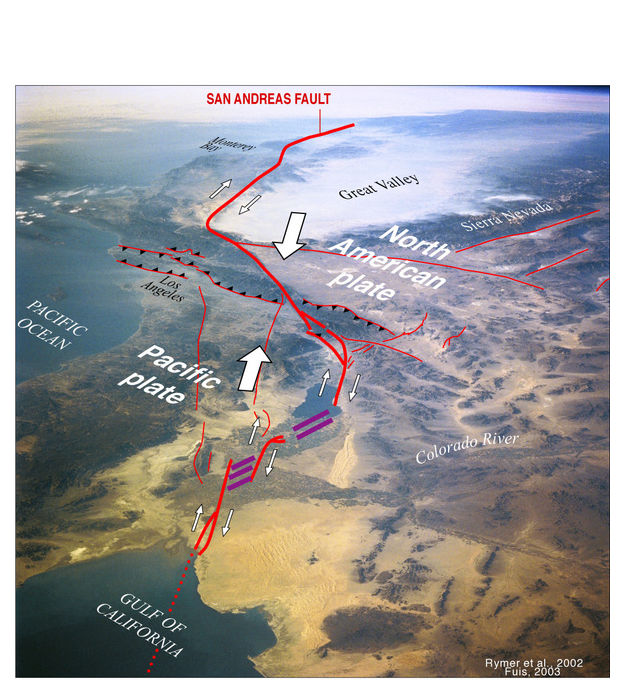
If you travel from Riverside, east on the 10, you'll soon come to the city of Banning in the San Gorgonio Pass. Banning is a small town that sits on the point of the "V" shaped gräben that comprises the previously mentioned counties. Traveling further east through Cabazon and into the heart of Imperial Valley, the elevation drops from 7oo' to below sea level in the city of Indio. This is the obvious change the East Pacific Rise has had on the suroundings, but there is an even more exciting transformation on the landscape: volcanoes.
Thanks to all that widening and thinning of the crust, magma can more easily find an avenue to the surface. There are five volcanoes or more precisely, five rhyolite domes at the south end of the Salton Sea: Rock Hill, Mullet Island, obsidian Butte, Red Island (Red Island has two domes). For the technical information, I turn to C. Dan Miller's thorough report (1989, Potential Hazards from Future Volcanic Eruptions in California:
USGS Bulletin 1847)
on the area; here are the specs:
- The Salton Buttes rhyolite center:
- Most recent eruption: Silicic pyroclastic and extrusive eruptions at four vents approximately 16,000 years ago (Potassium-Argon dating);
- Five silicic domes erupted;
- At least one silicic lava flow associated with rhyolite dome;
- Probable small-volume pyroclastic eruptions with tephra associated with dome emplacement at several vents;
- No recognized debris avalanches or debris flows;
- Most probably future potential hazard: Explosive and extrusive rhyolitic eruptions; phreatic and phreato-magmatic eruptions.
- Although the youngest eruptions in this area are not known to have produced
pyroclastic flows and surges, the compositions of lavas of past eruptions and
the association of vents with ground water and the Salton Sea suggest that
pyroclastic flows and surges and explosive eruptions could occur in the future.
Such events commonly are destructive out to distances of at least 10 kilometers
(6 miles) from an active vent.
- ... and from: Robinson, Elders, and Muffler, 1976, Quaternary volcanism in the Salton Sea geothermal field, Imperial Valley, California: GSA Bulletin 87, p.347-360, March 1976
- The Salton Sea geothermal field lies in the Salton Trough, the landward extension of the Gulf of California, an area of active crustal spreading. The Salton Buttes volcanoes lie within the Salton Sea geothermal field where temperatures measured in wells drilled for geothermal brines range up to 360 degrees C at depths of 1,500 to 2,500 meters (Helgeson, 1968). The wells produce a hot brine containing up to 160,000 ppm of dissolved solids, chiefly Cl, Na, K, Ca, and Fe (White, 1968). Under the influence of this hot saline brine, the sediments of the Salton Trough are being transformed into metamorphic rocks of the greenschist facies (Muffler and White, 1969).
From this information alone, one can see that even a phreato-magmatic eruption, an eruption that occurs when hot magma encounters saltwater, shouldn't be devastating to areas such as San Diego or Los Angeles. In short, lots of drama without a major impact other than on those living within the Brawley seismic zone, a large agricultural area south of the Salton Sea. The wind generally blows from the NW due to constriction via canyon walls; the ventifacts (rocks shaped by the wind) tell us that the wind has been blowing from this direction for many, many years. Also, west of the Salton, there is a field of Barchan Sand Dunes that attest to the strength of a wind blowing from one general direction.
South and East of the Salton Sea, one can find along dirt back roads, mudpots--some as large as 8' tall. Most are smaller and look much like crawfish holes dug out of Missouri gumbo (gumbo is a thick, gooey type of soil that contains rich sediments that enable the Boot Heel farmers to grow anything from rice to cotton to soybeans). Near Frink and around Calipatria, there are many such mudpots bubbling and passing the pungent gases that are released from far below the soil.Even around Rock Hill, near the shoreline, the water bubbles as the Salton's water level has increased and has submerged the mudpots and hot springs.
Back to Miller's report on volcanic hazards in the US, here is a graph from the same that outlines the potential area that would be affected by a future eruption and below this figure, there is an explanation for the type of hazard for this particular color coded zone.


Let's take a quick glance at the geothermal plants in the area:
 From the Land Use Database, comes the following:
This cluster of seven geothermal plants is the largest of three major geothermal energy production sites in the Imperial Valley. A network of deep wells drilled in the geothermal field allow water, heated by the earth's mantle, to come to the surface and to power electrical generators. Owned by the CalEnergy Company, the electricity is sold to the local power utility and put on the grid. The seven plants in this field produce enough electricity to power over 100,000 homes.
In the next post, I'll go into more detail about the volcanoes, as well as to provide personal pictures taken on some of my adventures there. Stay tuned...
Lin aka Roxxfoxx
South and East of the Salton Sea, one can find along dirt back roads, mudpots--some as large as 8' tall. Most are smaller and look much like crawfish holes dug out of Missouri gumbo (gumbo is a thick, gooey type of soil that contains rich sediments that enable the Boot Heel farmers to grow anything from rice to cotton to soybeans). Near Frink and around Calipatria, there are many such mudpots bubbling and passing the pungent gases that are released from far below the soil.Even around Rock Hill, near the shoreline, the water bubbles as the Salton's water level has increased and has submerged the mudpots and hot springs.
Back to Miller's report on volcanic hazards in the US, here is a graph from the same that outlines the potential area that would be affected by a future eruption and below this figure, there is an explanation for the type of hazard for this particular color coded zone.
Let's take a quick glance at the geothermal plants in the area:
This cluster of seven geothermal plants is the largest of three major geothermal energy production sites in the Imperial Valley. A network of deep wells drilled in the geothermal field allow water, heated by the earth's mantle, to come to the surface and to power electrical generators. Owned by the CalEnergy Company, the electricity is sold to the local power utility and put on the grid. The seven plants in this field produce enough electricity to power over 100,000 homes.
In the next post, I'll go into more detail about the volcanoes, as well as to provide personal pictures taken on some of my adventures there. Stay tuned...
Lin aka Roxxfoxx

nice job
ReplyDelete-rex sates
Thank you!!!
Delete