Monday, September 8, 2014

Barðarbunga at Holuhraun Video and Latest Info 09/08/2014


Toxic Volcano Tornados Spotted in Iceland

Volcano tornado in Iceland
Volcano tornados spotted above lava on Sept. 1 at Iceland's Holuhraun eruption.
Credit: Einar Gudmann
Hollywood, death by lava is such a cliché. No worries, though: Iceland is here to help. Last week, the country's cold, stormy weather and blazing volcanic eruption hatched a terrifying new way to die at volcanoes — the volcano tornado.
 

The toxic tornadoes were spotted in a poisonous cloud of sulfur dioxide gas spewing from Iceland's Holuhraun lava flow on Sept. 3. One narrow, swirling column stretched 3,300 feet (about 1 kilometer) into the air. A remotely monitored infrared camera caught the dramatic whirlwinds on video.

"We haven't seen anything like this before," said Fred Prata, chief technology officer at Nicarnica Aviation in Kjeller, Norway, the inventor of the infrared camera used for the images. "I was quite surprised to see it."


Nicarnica's infrared camera can track ash clouds from planes, but is now undergoing a ground-based test run in Iceland through the FutureVolc project, an international collaboration to monitor Europe's natural hazards.

The volcano tornado was most likely a spinning ribbon of sulfur dioxide gas, similar to a fire tornado, Prata told Live Science.

Tornadoes born from fires and volcanoes are completely different beasts from the lethal tornadoes spawned by powerful thunderstorms. A true tornado spins up in the atmosphere and requires colliding cool and dry air fronts, wind shear (rotating air) and warm, moist air near the ground.

But narrow volcano and fire whirlwinds rise from ground level, not from high in the sky. In these terrible twisters, superheated dry air starts spinning faster and faster until the vortex tightens into a tall, tornadolike column. (The phenomenon is similar to a figure skater who rotates faster by tucking her arms closer to her body.)

On Sept. 3, 2014, gas tornadoes (seen here in infrared) spewed from Iceland's Holuhraun lava flow, near the Bardarbunga volcano.
Credit: Nicarnica Aviation, Screengrab


The Icelandic Met Office has warned of the risk of volcano tornadoes, though its official terminology refers to the phenomenon as "wind anomalies from thermal convection." Last week, officials arrested tourists who ventured too close to the hazard zone. Scientists and journalists were also asked to leave the lava field the same day the volcano tornadoes appeared, due to the hazardous conditions.
Despite the risks, professional photographer Einar Gudmann also caught the volcano tornadoes in action on Sept. 1, and posted photos on his website.

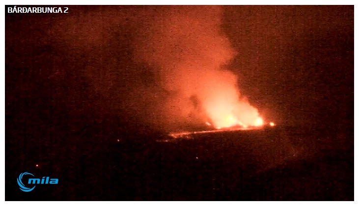
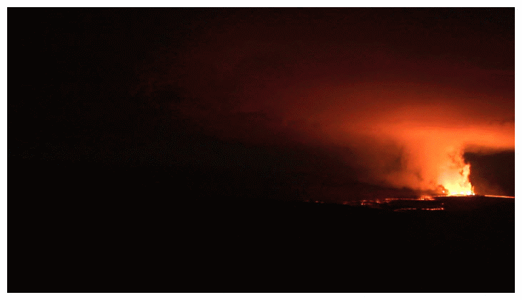
Iceland's eruption blazed to life on Aug. 28 north of Bardarbunga volcano, in the Holuhraun lava field. The basalt lava flow is now plowing through the Jokulsa a Fjollum River as of Sept. 7, diverting but not blocking the channel. The glowing lava covers 7.3 square miles (19 square km).

source

~~~~~~~~~~~~~~~~~~~~~~~~~~~~~~~~~~~~~~~~~~~~~~~~~~~~~~~~~~~~~~~~~~~~~~~~~

Continuing subsidence in Barðarbunga

Flokkar: Volcano
Bardarbunga volcano on Sept. 5. (Picture: Magnus Tumi Gudmundsson)
  • Prenta
  • Senda frétt
A surveillance flight over the Bardarbunga volcano this morning revealed continuing subsidence of the 850 metre thick glacial ice which covers the caldera beneath. Strong seismic activity is still detected around the caldera; the last one, a magnitude 5.0 earthquake occurred at 14.47 GMT.
Following a surveillance flight last Friday over the Bardarbunga caldera, when measurements revealed up to 15 meter subsididence in the center of the caldera, another flight was organized this morning.

The results show that the downward movement continues; since Friday the subsidence has increased by 2.5 - 3.0 metres, or 80-90 centimeters per day. "The events in Bardarbunga can only be described as a slow caldera collapse," says statement on the University of Iceland´s Institute of Earth Sciences´ website. The subsidence is the largest one measured in an Icelandic volcano.

These events are belived to occur in relation to the magma flow out of a chamber, thought to be situated beneath the caldera in Bardarbunga, as magma has been flowing to the north, feeding the effusive eruption in Holuhraun which started last week.

According to a status report issued Saturday, by the Icelandic Civil Protection Agency´s Scientific Advisory Board, the initial measurements from Friday showed dramatic changes on the surface of the glacier above the caldera,  corresponding to a volume change of 0.25 cubic kilometres, or 250 million cubic meters.

bjornm@ruv.is

Below, the preliminary result of todays surveillance flight, titled: Bardarbunga - subsidence of glacial surface (University of Iceland/Institute of Earth Sciences.


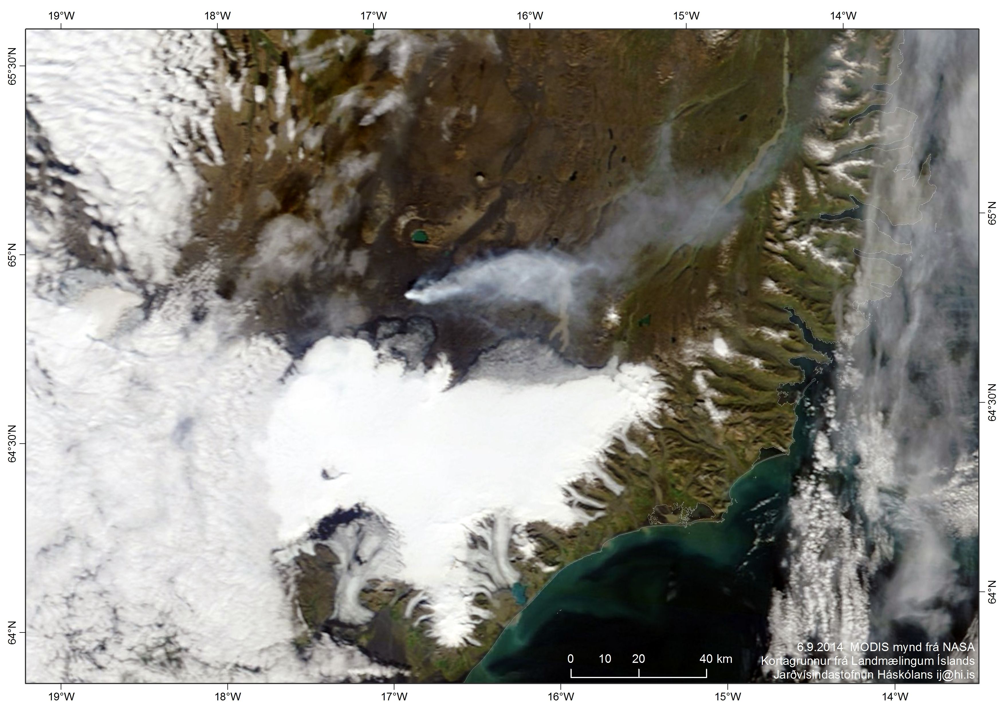
And for a very cool series of images, go here to view them: LINK

Sunday, September 7, 2014

Barðarbunga at Holuhraun Update for 09/07/2014

7th September 2014 19:00 - from geoscientist on duty

Today, most of the earthquakes have been located in Bárðarbunga caldera, at the eruption site, in Dyngjujökull and at Herðubreiðatögl. The two largest events occurred this morning (M4.6 and M5.4) at 3:27 and 7:07 UTC in Bárðarbunga caldera. We have recorded about 155 earthquakes since this morning and the seismic tremor has been lower than yesterday.
Earth scientists in the field report that the eruptive activity in the northernmost part of the north-fissure has no more lava fountaining, whereas the central craters are the most active like previous days. The new fissure in the south shows no visible activity since this afternoon.

7th September 2014 13:00 - from the Scientific Advisory Board

  • The eruptive activity at Holuhraun has not decreased. Magma flow is between 100 and 200 m3/s. The lava advances by about 1 km/day and its area yesterday afternoon was around 16 km2. The eruption sites are the same as before. The eruptive intensity on the southern fissure that opened on Friday is much less than on the northern fissure that has been active since the beginning of the eruption.
  • The lava tongue now extends 11 km to the north and has reached the western main branch of Jökulsá á Fjöllum river. However, no explosive activity due to the lava and river water interaction has been observed, but steam rises from the lava. A white eruption cloud rises 3 - 4 km and is directed to the north and northeast.
  • Seismicity in the area is similar to yesterday. Around 140 earthquakes have been recorded since midnight. At 03:30 this morning, a magnitude 4.6 earthquake occurred at the rim of the Bárðarbunga caldera. Shortly after 07:00, a magnitude 5.4 earthquake occurred on the rim, one of the largest recorded since the start of the present activity. The amount of magma flow into the dyke seems to be similar to the magma erupting from the fissures.
  • The scenarios are the same as before. The factsheet from the meeting (pdf, 0.2 Mb).
from the Icelandic Met Office


Barðarbunga at Holuhraun New Videos


Drone Catches Incredible Video Footage of Yasur Erupting


> Drone Catches Incredible Video Footage of Volcano Spewing Lava - Photo posted in Wild videos, news, and other media | Sign in and leave a comment below!
Vanuatu Volcano

 
An unmanned flying helicopter drone has captured incredible close-up video footage of a live volcano erupting in Vanuatu, an island nation just off the coast of Australia, according to DroneHire.org.

Drone operator Shaun O'Callaghan sent his DJI Phantom 2 quadcopter drone armed with a GoPro camera to the crater at the top of Mount Yasur, an active volcano that stands 361 metres above sea level and is considered to be one of the most easily accessible live volcanos in the world.

The drone was able to dodge scorching debris and lava at temperatures of up to 1,200 degrees Celsius, record the footage and still return safely to its owner.

The Phantom drone is one of the most highly regarded flying drones as it is very durable and can manage an above-average flight time of 25 minutes.

Ordinary aircraft have never been able to get this close to a live volcano as the smoke and debris pose a great danger since they can interfere with aircraft engines and helicopter rotor blades.

New Holuhraun Eruption Videos


Saturday, September 6, 2014

Barðarbunga at Holurhaun (the images) from last night and tonight


Barðarbunga at Holurhaun Update (by the officials)

Update from IMO 6. September 2014 at 10.01 pm
Earthquake activity today has been in similar places as recent days, in Bárðarbunga
caldera, at the eruption site, Dyngjujökull and at Herðubreiðatögl. Two earthquakes
4,4 and 4,3 were recorded in Bárðarbunga caldera in the afternnon, at 14:32 and
18:43 respectively, but this morning at 05:40 a magnitude 5 was measured in a
similar location. The total number of recorded earthquakes since midnight is around
170. Earth scientists at the eruption site think that the eruptive activity is
similar as yesterday. Seismic tremor has low amplitudes today .

source

6th September 2014 - the subsidence of the glacier surface

""
Bárðarbunga. Subsidence of the glacier surface (m). A comparison of the measurement of TF-FMS yesterday and a Lidar map from 2011 as well as surface measurements from June this year. Institute of the Earth Sciences, University of Iceland.

6th September 2014 12:00 - from the Scientific Advisory Board

Scientists from the Icelandic Met Office and the Institute of Earth Sciences and representatives of the Civil Protection in Iceland attend the meetings of the Scientific Advisory Board of the Icelandic Civil Protection.

Conclusions of the Scientific Advisory Board of the Icelandic Civil Protection:

  • In the surveillance flight yesterday the ice-surface at Bárðarbunga was measured with the radar system of Isavia's aircraft. The measurements show large changes on the ice-surface. Up to 15 m subsidence has occurred in the centre of the caldera, which corresponds to a volume change of 0.25 km³. The shape of the subsidence area is in accordance with the elevation of the caldera floor having lowered by that amount.
    • Subsidence of this order has not been observed in Iceland since measurements of crustal movements started around the middle of last century.
    • No signs of eruption or increased geothermal activity in the Bárðarbunga caldera are observed.
    • The volume of the subsidence in Bárðarbunga is considerable portion of the total volume of the magma dyke.
    • The most probable explanation is that this subsidence is related to the recent high seismic activity and subsurface magma flow to the northeast.
  • In the surveillance flight yesterday a shallow, wide depression was observed on the surface of Dyngujökull, 10 km from the glacier edge. Another depression 6 km from the Dyngjujökull ice edge, which has been monitored over the last few days has deepened and is now 35 m deep.
    • It is likely that these depressions are signs of small and short subglacial eruptions.
  • The eruptive activity at Holuhraun is the same as yesterday.
    • Two eruptive fissures are active. The main activity is on the same fissure that has been active since the eruption began. In addition the fissure that opened yesterday morning is still active.
    • The lava now extends 10 km ENE and has just under one km to reach Jökulsá á Fjöllum river.
  • Seismic activity has decreased since yesterday. Approximately 90 earthquakes have been detected since midnight. One earthquake, of magnitude 5 was located in the Bárðarbunga caldera at 05:40 UTC. 14 earthquakes of magnitudes greater than 5 have been located since 16 of August.
  • Deformation changes since yesterday, measured with GPS north of Vatnajökull are small.
  • Four scenarios are still likely:
    • The migration of magma could stop, resulting in a gradual reduction in seismic activity and no further eruptions.
    • The dyke could reach the Earth's surface at different locations outside the glacier. Lava flow and/or explosive activity cannot be excluded.
    • The intrusion could again reach the surface under the glacier and possibly lead to a significant  eruption. This would most likely produce a flood in Jökulsá á Fjöllum and perhaps explosive, ash-producing activity.
    • An eruption in Bárðarbunga. The eruption could cause an outburst flood and possibly an explosive, ash-producing activity. In the event of a subglacial eruption, it is most likely that flooding would affect Jökulsá á Fjöllum. However it is not possible to exclude the following flood paths: Skjálfandafljót, Kaldakvísl, Skaftá and Grímsvötn.
  • Other scenarios cannot be excluded.

From the Icelandic Met Office:

The Aviation Colour Code for Bárðarbunga remains at ‘orange' and the code for Askja at ‘yellow'.
This factsheet is available as pdf (0,3 Mb).

6th September 2014 - the area and the plume

Above all
""
Landsat 8 satellite image (false colours) from NASA & USGS since 12:27 today. The image has been processed by the Institute of Earth Sciences, University of Iceland, for the purpose of distinguishing individual lava streams within the lava field. Enlarge.
The plume at noon
""
The plume is clearly visible on this MODIS satellite image from NASA at noon. Enlarge.
Lava day by day
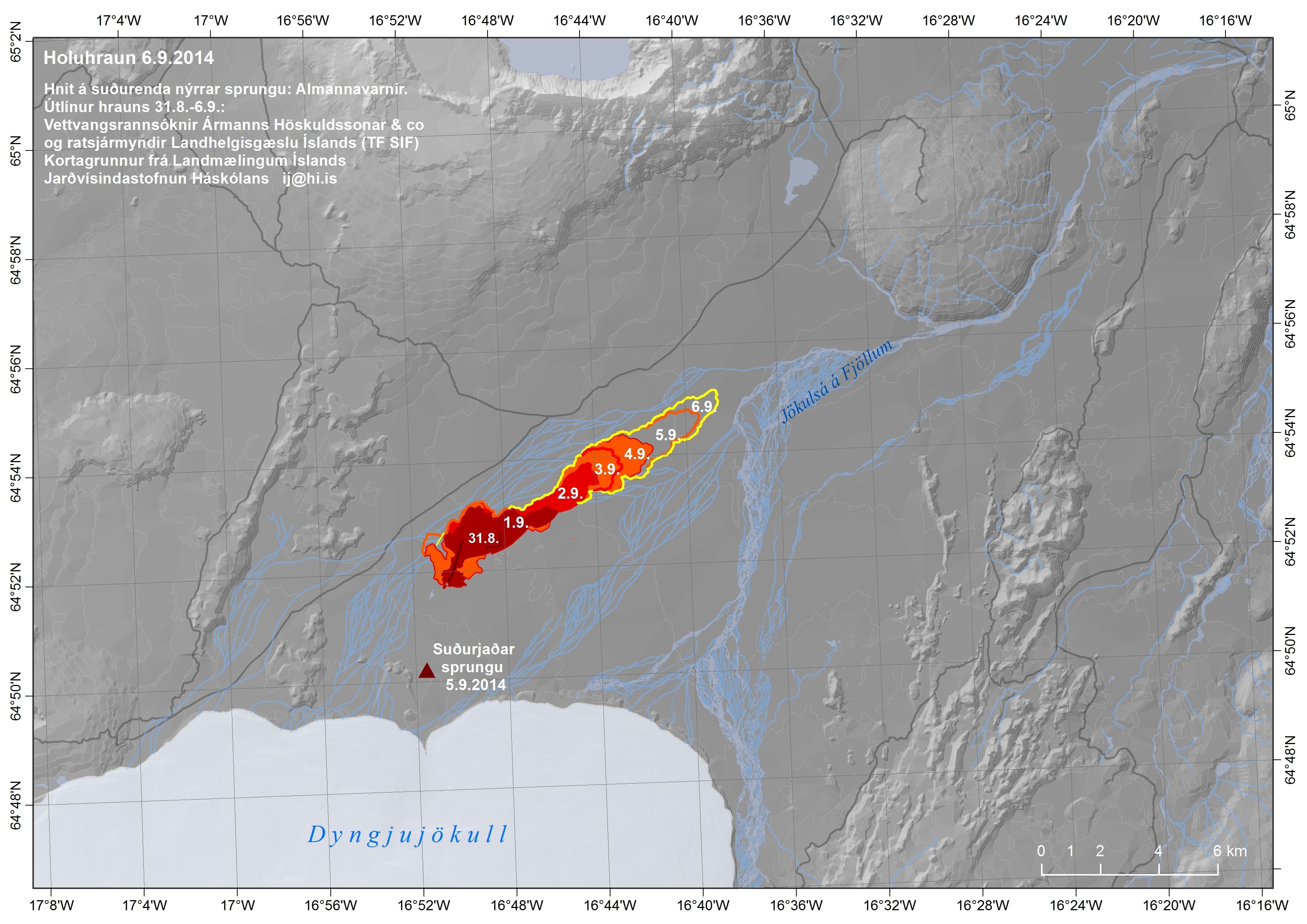
"" Institute of Earth Sciences University of Iceland 6.9.2014: South coordinates from surveillance flight. Edges of lava 31.8-6.9. based on radar images from TF-SIF of the Coast Guard and GPS measurements from the field (IES). Map base from the National Land Survey.
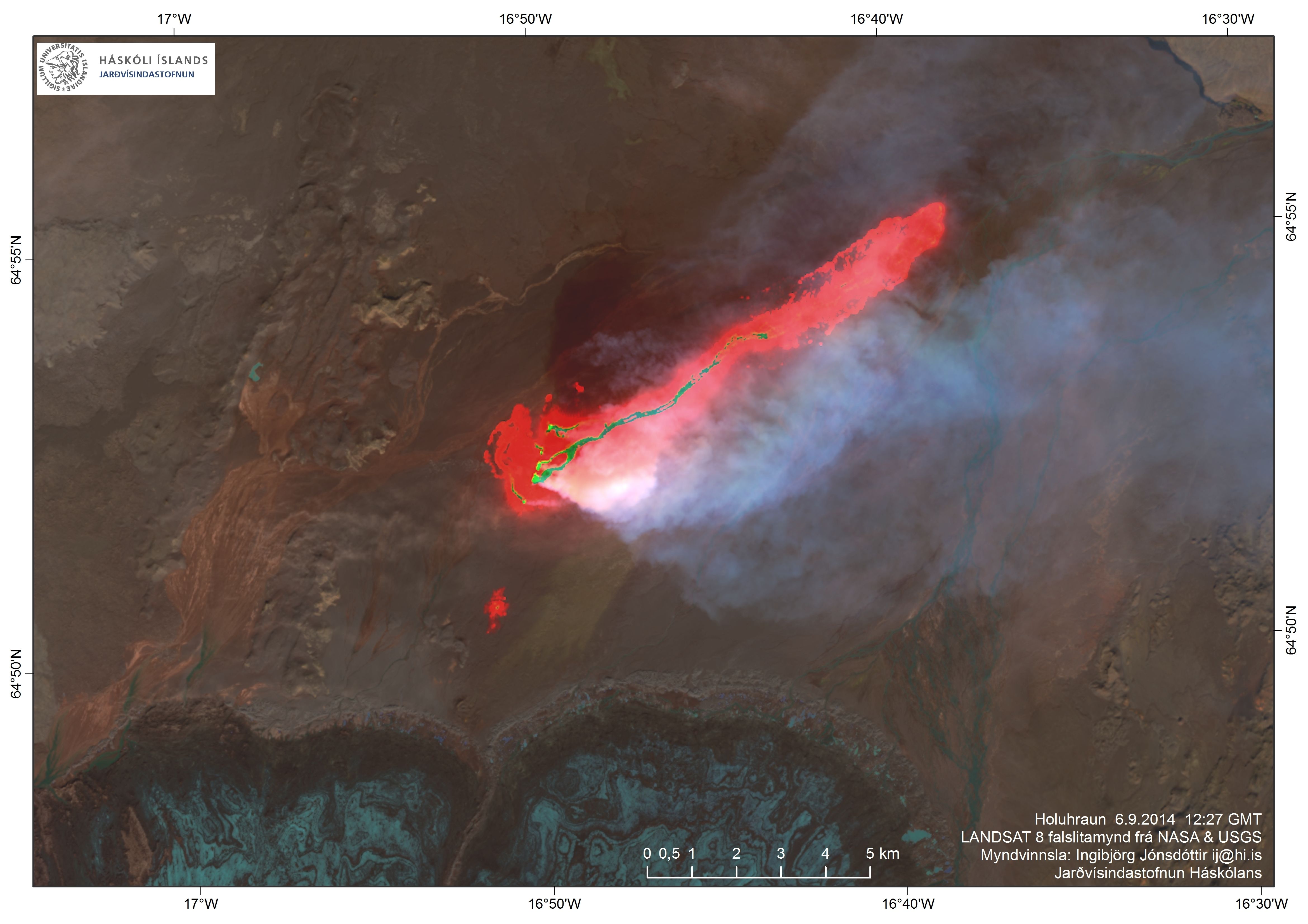
 Enlarge. Excluding the southern contribution, the area of this lava is 14.8 km².

source