An increased number of
earthquakes have been detected in and around Bárðarbunga volcano under
Vatnajökull glacier in the past days. In the last 24 hours, almost 130
earthquakes have been detected at Bárðabunga and about 30 in the
northern part of the intrusive dike.
The dike channels magma from Bárðarbunga to the Holuhraun eruption site north of Vatnajökull.
No quakes above 5.0 in magnitude have been detected in the area since
October12, but five quakes between magnitude 4.5 and 4.8 hit yesterday, the Icelandic Met Office reported in its latest update this morning.
The eruption continues at a similar intensity. It was clearly visible on webcams from midnight until almost 8 this morning.
source
Sunday, November 16, 2014
Friday, November 7, 2014
Thursday, October 30, 2014
Roundtrip to Hell - Barðarbunga Volcano Expedition (A-mazing video!)
More Earthquakes in Bárðarbunga, Heat Increases
Bárðarbunga. Photo: Páll Stefánsson.
Geothermal heat continues to increase in Bárðarbunga. Scientists on a surveillance flight above the volcano yesterday could clearly see cauldrons that had formed in the glacier on the western and southeastern rim of the caldera, ruv.is reports.
The largest cauldron has deepened by 25 meters (82 feet) in one month. Scientists link this development to the subsidence of the caldera, which now measures 40 meters. The subsidence cannot be detected with the naked eye as the caldera is 8 km wide.
The eruption in Holuhraun, north of Vatnajökull, continues. The lava erupting in a fissure there originates in the Bárðarbunga magma chamber and is channeled to the eruption site via an intrusive dike, which formed underground before the eruption started in August.
The eruption is visible on webcams, including one established by telecommunication company Míla in August.
source
Sunday, October 26, 2014
Saturday, October 25, 2014
How much lava has erupted from Holuhraun?
Extention of lava field in Holuhraun, updated to today. Please click on image for larger size.
Sources: Twitter
@gislio@almannavarnir
@uni_iceland
@EmaMaiorana
Sources: Twitter
@gislio
@uni_iceland
@EmaMaiorana
Monday, October 20, 2014
Holuhraun at Barðarbunga Eruption Update 10/19/2014
Fissure Eruption Update
Experts at Discover The World and Ari Trausti Guðmundsson
19/10/2014
The lava outpouring from the short fissure at Holuhraun has now remained steady for weeks. Three interconnected vents (300-400 m long) are what remains of the original 1.9-km-long, once active fissure. The height of the crater hill around the vents exceeds 100 m, taking the form of a lava shield (also known as a shield volcano) - see the image from the Geoscience institute by geoscientist Morten Riishuus. The big regional dyke is still going strong and the eruption could remain active for many years or die down within a few weeks or months. Further breaching of the surface along the dyke leading to a subglacial eruption in the Dyngjujökull outlet glacier is still possible.
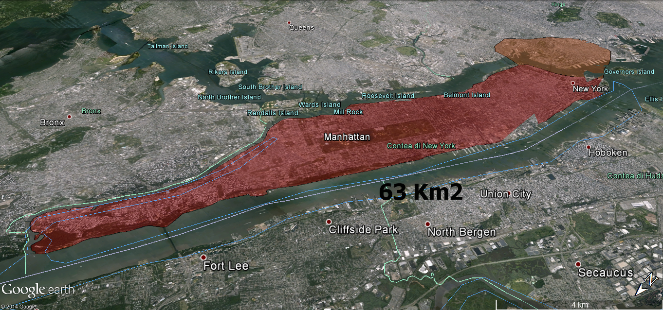
The lava flow now has an area of roughly 60km² and a volume of approximately 800 million cubic metres (0.8 cu. km). The Hekla lava flow is somewhat similar in size but was generated in 13 months. Therefore, the highlands will soon become the largest lava flow occurring within such a short interval in Iceland - since the late 18th century. New trace elements and isotope analysis are said to indicate a magma source at a depth of at least 15 km.
The included map is from the Geoscience Institute and the Coast Guard (October 17th).
The Bárðarbunga central volcano continues to shudder, with dozens of earthquakes every day. On October 18th, two earthquakes were recorded with a magnitude 4.7 and 5.0, with a further two on the 19th with a magnitude of 5.2 and 4.5. Currently, the depression in the caldera ice dome is over 35 m deep. The main earthquake location is at the northern rim of the caldera or at the volcano flank in the north. GPS-readings over a period of a few days show both dilation and/or doming of the volcano.
Reverse faulting has been detected from some earthquakes. Another earthquake location is at the south-eastern rim. Practically no earthquakes originate in the caldera floor. With time, a simple model of caldera floor subsidence and a direct link between a Bárðarbunga magma chamber and the big dyke seems more and more unlikely.
I have stressed before, as have prof. Águst Guðmundsson (Royal Holloway – University of London) and prof. Þorvaldur Þórðarson (University of Iceland) in talks and in an article (in the Bulletin of Volcanology), that a large magma reservoir, is the possible site of the magma influx into the dyke.
Independently of this, the roots and the non-verified (but naturally alleged), shallow magma chamber remains beneath the caldera, a theory consistent with chemical signals in the magma. The magma from a deeper reservoir is probably being injected into the volcano, even as ring dykes. It remains to be seen if this hypothesis is correct but many indications are present.
There is no way to predict what will happen at Bárðarbunga; small or large eruptions may occur, and similar tectonic movements or a sudden caldera collapse could become the result of the processes in the volcano.
The many scenarios presented by the Civil Protection and its Scientific council are still valid.
The nearby Tungnafellsjökull central volcano (with a caldera), west of Bárðarbunga, has been the site of over 150 earthquakes (with the majority of them with magnitude less than 3.0). Most of them have loci at shallow depth but some originate much deeper, at up to 20 km plus. This probably indicates an influx of magma but the GPS-readings do not support that, so far. Magma intrusions in a volcano do not automatically lead to eruptions.
It is interesting to note that the Kverkfjöll central volcano (with two calderas), the next neighbour of Bárðarbunga in the east is showing very little tectonic activity. Only a few dozen quakes have originated there and the same story can be said about the very active Grímsvötn central volcano southeast of Bárðarbunga. It is, at any rate, important to follow the development of all nearby volcanoes with care.
More elaborate seismic and GPS monitoring would help in revealing the processes at hand below the earth´s surface in this very active part of Iceland.
Compiled by: Geoscience Institute of the University of Iceland/Coast Guard
Map base: The Geodetic Survey.
Photo: Morten Riishuus, Geoscience Institue
Dates: 28th of Sept. and 15th of Oct.
source
Experts at Discover The World and Ari Trausti Guðmundsson
19/10/2014
The lava outpouring from the short fissure at Holuhraun has now remained steady for weeks. Three interconnected vents (300-400 m long) are what remains of the original 1.9-km-long, once active fissure. The height of the crater hill around the vents exceeds 100 m, taking the form of a lava shield (also known as a shield volcano) - see the image from the Geoscience institute by geoscientist Morten Riishuus. The big regional dyke is still going strong and the eruption could remain active for many years or die down within a few weeks or months. Further breaching of the surface along the dyke leading to a subglacial eruption in the Dyngjujökull outlet glacier is still possible.
The lava flow now has an area of roughly 60km² and a volume of approximately 800 million cubic metres (0.8 cu. km). The Hekla lava flow is somewhat similar in size but was generated in 13 months. Therefore, the highlands will soon become the largest lava flow occurring within such a short interval in Iceland - since the late 18th century. New trace elements and isotope analysis are said to indicate a magma source at a depth of at least 15 km.
The included map is from the Geoscience Institute and the Coast Guard (October 17th).
The Bárðarbunga central volcano continues to shudder, with dozens of earthquakes every day. On October 18th, two earthquakes were recorded with a magnitude 4.7 and 5.0, with a further two on the 19th with a magnitude of 5.2 and 4.5. Currently, the depression in the caldera ice dome is over 35 m deep. The main earthquake location is at the northern rim of the caldera or at the volcano flank in the north. GPS-readings over a period of a few days show both dilation and/or doming of the volcano.
Reverse faulting has been detected from some earthquakes. Another earthquake location is at the south-eastern rim. Practically no earthquakes originate in the caldera floor. With time, a simple model of caldera floor subsidence and a direct link between a Bárðarbunga magma chamber and the big dyke seems more and more unlikely.
I have stressed before, as have prof. Águst Guðmundsson (Royal Holloway – University of London) and prof. Þorvaldur Þórðarson (University of Iceland) in talks and in an article (in the Bulletin of Volcanology), that a large magma reservoir, is the possible site of the magma influx into the dyke.
Independently of this, the roots and the non-verified (but naturally alleged), shallow magma chamber remains beneath the caldera, a theory consistent with chemical signals in the magma. The magma from a deeper reservoir is probably being injected into the volcano, even as ring dykes. It remains to be seen if this hypothesis is correct but many indications are present.
There is no way to predict what will happen at Bárðarbunga; small or large eruptions may occur, and similar tectonic movements or a sudden caldera collapse could become the result of the processes in the volcano.
The many scenarios presented by the Civil Protection and its Scientific council are still valid.
The nearby Tungnafellsjökull central volcano (with a caldera), west of Bárðarbunga, has been the site of over 150 earthquakes (with the majority of them with magnitude less than 3.0). Most of them have loci at shallow depth but some originate much deeper, at up to 20 km plus. This probably indicates an influx of magma but the GPS-readings do not support that, so far. Magma intrusions in a volcano do not automatically lead to eruptions.
It is interesting to note that the Kverkfjöll central volcano (with two calderas), the next neighbour of Bárðarbunga in the east is showing very little tectonic activity. Only a few dozen quakes have originated there and the same story can be said about the very active Grímsvötn central volcano southeast of Bárðarbunga. It is, at any rate, important to follow the development of all nearby volcanoes with care.
More elaborate seismic and GPS monitoring would help in revealing the processes at hand below the earth´s surface in this very active part of Iceland.
Map base: The Geodetic Survey.
Dates: 28th of Sept. and 15th of Oct.
source
Wednesday, October 15, 2014
Increased Earthquakes at Bárðarbunga Volcano
Bárðarbunga. Photo: Páll Stefánsson.
Tuesday, October 14, 2014
Brand new images of the Holuhraun eruption
According to Gísli Gíslason, pilot at Norðurflug, the eruption at Holuhraun was particularly impressive on Friday. There has been some snowfall in the eruption area and copious amounts of lava was spouting from the crater. " The eruption seemed to have gained power today," said Gislason but according to the National Meterological Institute the situation is similar to recent days.
Flights over the eruption area have been difficult in the past few days due to heavy fog.
Images courtesy of Norðurflug.
source
Thursday, October 9, 2014
Barðarbunga Eruption
Bardarbunga Eruption, 9.11.-13.2014
First part seen from 50km distance under Northern Lights, timelapse animation. Second part showing Lava Fountains from approx. 1km distance. Note the Airplane at 1:00 - 1:02 giving scale.
Tuesday, October 7, 2014
Bárðarbunga Volcano Keeps Shaking
The Holuhraun eruption continues at a similar intensity. Photo: Jóhannes Benediktsson.
Almost 30 earthquakes
have occurred in and around Bárðarbunga volcano under Vatnajökull
glacier since 7 pm yesterday, according to the Icelandic Met Office’s update this morning. Three quakes were larger than magnitude 4.0—a magnitude 5.0 earthquake hit at 3:52 am.
The volcanic eruption in Holuhraun continues at a similar intensity as in previous days, as stated in the latest status report issued by the Civil Protection Department’s National Crisis Coordination Center yesterday afternoon.
The lava production from the fissure in Holuhraun remains steady with lava flowing to the southeast into glacial river Jökulsá á Fjöllum. The subsidence of the Bárðarbunga caldera continues at a similar rate, the report concluded.
More than 40 earthquakes above magnitude 5.0 have been recorded in Bárðarbunga since August 16, ruv.is reports. The strongest of these—the strongest quake recorded in Iceland since 2008—was of magnitude 5.7, hitting on August 26, shortly before the Holuhraun eruption started on August 29.
Yesterday’s status report stated that the size of the largest earthquakes in Bárðarbunga has now subsided slightly and very little seismic activity is now detected in the northern part of the intrusive dike, connecting Bárðarbunga to Holuhraun, and around the eruption site.
source
The volcanic eruption in Holuhraun continues at a similar intensity as in previous days, as stated in the latest status report issued by the Civil Protection Department’s National Crisis Coordination Center yesterday afternoon.
The lava production from the fissure in Holuhraun remains steady with lava flowing to the southeast into glacial river Jökulsá á Fjöllum. The subsidence of the Bárðarbunga caldera continues at a similar rate, the report concluded.
More than 40 earthquakes above magnitude 5.0 have been recorded in Bárðarbunga since August 16, ruv.is reports. The strongest of these—the strongest quake recorded in Iceland since 2008—was of magnitude 5.7, hitting on August 26, shortly before the Holuhraun eruption started on August 29.
Yesterday’s status report stated that the size of the largest earthquakes in Bárðarbunga has now subsided slightly and very little seismic activity is now detected in the northern part of the intrusive dike, connecting Bárðarbunga to Holuhraun, and around the eruption site.
source
Monday, October 6, 2014
Saturday, October 4, 2014
Dead hiker's posthumous photograph captures Japanese volcano's ash cloud sweeping towards him moments before it claimed his life
- Images taken last Saturday by hiker Izumi Noguchi show the moments immediately after Mount Ontake erupted
- The 59-year-old's body was later found near the volcano's summit shrine compound with his camera close by
- His wife Hiromi has now opted to make the haunting images public as a tribute to her late husband's memory
- Massive eruption left at least 47 people dead, with a further 16 people - the majority hikers - still unaccounted for
By
John Hall for MailOnline
Published:
3 October 2014
These
haunting photographs capture the huge cloud of ash from a Japanese
volcano that swept towards a hiker just seconds before killing him.
The
images - which were taken last Saturday on Mount Ontake - show the
moments immediately after the volcano erupted, sending dense plumes of
gas and ash high into the sky and leaving at least 47 people dead, with a
further 16 people still unaccounted for.
Among
the victims of the volcano was 59-year-old hiker Izumi Noguchi, whose
body was found near Mount Ontake's summit shrine compound.
Search
and rescue teams recovering his body discovered his camera and among
the photographs he had taken were images of the a huge cloud of ash
creeping ever closer to him following the eruption. His wife Hiromi has
now opted to make the images public as a tribute to Mr Noguchi's
memory.
The
images emerged as doctors determined that almost all of those killed on
Mount Ontake died of injuries relating to rocks flying out of the
volcano.
Scroll down for video
Final photograph: Izumi Noguchi took
this incredible photograph of a huge cloud of ash from Japanese volcano
Mount Ontake just moments before he was killed. His body and camera were
found near Mount Ontake's summit shrine compound
Tragic: Izumi Noguchi's images - which
were taken last Saturday on Mount Ontake - show the minutes immediately
after the volcano erupted, sending dense plumes of gas and ash high
into the sky and leaving at least 47 people dead, with a further 16
people still unaccounted for
Gesture:
Among the victims of the volcano was 59-year-old hiker Izumi Noguchi
(above) who took the photographs of the ash cloud. His wife Hiromi
(below) has now opted to make the images public as a tribute to Mr
Noguchi's memory
Rescuers
have retrieved 47 bodies from the ash-covered summit area of Mount
Ontake since Saturday's eruption. Authorities this morning announced
that another 16 people are still missing, with search efforts suspended
once again due to rain.
Doctors
concluded that all but one of the bodies showed signs of having been
hit by volcanic boulders and rocks, Nagano prefectural police said. The
other victim died of burn injuries caused by inhaling hot air.
Those
hit by the rocks and debris had multiple cuts and fractures,
particularly in the head and the back, as well as the legs, a
prefectural police official said on condition of anonymity, citing
department policy. Nagano police had earlier said the victims died of
'disaster,' without specifying the cause.
Most
of the bodies were found near Mount Ontake's summit, where many
climbers were resting or having lunch. Some bodies were retrieved from a
trail at a slightly lower elevation.
Experts
say hikers near the summit might have been hit by rocks flying as fast
as 190 miles per hour. Most of the ash fell in the first hour of the
explosion, according to the University of Tokyo's Earthquake Research
Institute.
Hunt: These handout pictures made
available today show rescuers from Japan's Ground Self-Defence Force
walking down a slope covered with deep volcanic ash. Workers have
retrieved 47 bodies from the ash-covered summit area of Mount Ontake
since Saturday's eruption
Eerie: A handout picture made
available today shows a mountain lodge covered with volcanic ash near
the peak of Mount Ontake. Authorities this morning announced that 16
people are still missing, with search efforts suspended once again due
to rain.
Grim: These
images made available today by Japan's Ground Self-Defence were
released as doctors confirmed that all but one of the 47 bodies they
have recovered showed signs of having been hit by volcanic boulders and
rocks. The other victim died as a result of burn injuries caused by
inhaling hot air
Survivors
said they fled for their lives as rocks and debris rained down on them
while they struggled with hot air and ash hitting their face.
Medical
experts who have examined some of the nearly 70 injured have said most
had bruises, cuts and bone fractures on their back, an apparent sign
they were hit by rocks flying out of the volcano. Some of the injured
reportedly had damage to their lungs and other organs due to the impact
of rocks hitting them.
The
eruption at Mount Ontake, located in central Japan, caught hikers by
surprise. Seismologists have said that increased seismic activity had
been detected at Ontake, one of 47 active volcanoes in Japan that are
under 24-hour monitoring, but that nothing signaled such a big eruption.
The
death toll is the highest from a volcanic eruption in Japan's postwar
history, exceeding the 43 people killed in the 1991 eruption of Mount
Unzen in southern Japan.
Ontake,
Japan's second-highest active volcano, last had a minor eruption seven
years ago. Researchers say predicting a steam-driven explosion is
especially difficult - and even harder with limited information about a
peak's past volcanic activity.
Japan
monitors 47 of its 110 active volcanoes around the clock, but the
research budget has always been less than for earthquakes and critics
say the equipment is insufficient.
Over
the last 10 years, volcano research in government institutions has
received an average 1.4 billion yen annually, compared to 7.6 billion
yen for earthquake studies, Education Ministry data shows.
'Maintenance
of monitoring devices has been delayed, and the equipment is getting
old,' Yasuo Ogawa, at the Tokyo Institute of Technology's Volcanic Fluid
Research Centre, told Reuters.
Hasegawa,
at the Japan Meterological Agency, said he was not aware of budget
changes and technology now allows real-time observations from afar.
Surveillance was extended in 2009.
Ogawa
disagrees. 'I don't think the network is adequate and there aren't
enough people,' he said. 'Hopefully, everybody can use this as an
opportunity to rethink things.'
source
~~~~~~~~~~~~~~~~~~~~~~~~~~~~~~~~~~~~~~~~~~~~~~~~~~~~~~~~~~~
source
~~~~~~~~~~~~~~~~~~~~~~~~~~~~~~~~~~~~~~~~~~~~~~~~~~~~~~~~~~~
PYROCLASTIC FLOWS: A DEADLY AVALANCHE OF GAS AND ROCKS
Pyroclastic
flows are one of the most destructive and deadly processes of a
volcanic eruption. The flows act and look like a body of liquid but are
actually composed of hot gas and rock. Formed inside the volcano by the
fragmentation of magma and rocks during the eruption, they travel down
the mountain slope at breakneck speeds, often incinerating everything in
their path.
The
flows act as a fast-moving current and appear similar to a snow
avalanche when they burst from the volcano. These flows, composed of
volcanic rock debris and toxic gases, are usually deadly as they can
reach speeds over 100 km/h and temperatures of 1,000 degrees.
Although
they are composed of gas and rock, the properties of pyroclastic flows
mean they act more like a liquid. The heavier debris moves along the
ground, covered by a gas plume which radiates upwards as it moves.
Depending on the size of the rock debris carried within them, they can
leave behind deep layers of rock fragments.
The
eruption at Mount Ontake likely triggered a pyroclastic surge, although
it is thought to have been relatively cold when compared to some other
documented flows.
Professor Emeritus of the University of Tokyo, Shigeo Aramak, told NHK World
the colour of the debris clouds seen in the footage of the erupting
Mount Ontake showed the temperature was relatively low for a pyroclastic
flow, which may mean magma was not present.
Friday, October 3, 2014
Bardarbunga volcano update
Scientists from the Icelandic Met Office and the Institute of Earth Sciences and representatives of the Civil Protection in Iceland attend the meetings of the Scientific Advisory Board of the Icelandic Civil Protection. A representative from The Environment Agency of Iceland was also present.
The eruption continues at a similar intensity as previous days. The lava production is steady and running to the southeast from the grader.
- Very high SO2 values were measured at the eruption site yesterday. It is estimated that 35.000 tons of SO2 are produced by the eruption daily.
- The subsidence of the Bardarbunga caldera continues with similar rate although the size of the largest earthquakes have subsided slightely over the last week.
- Eleven earthquakes greater than M3.0 were recorded since noon yesterday, the largest M4.8 at 01:41 yesterday.
- Smaller earthquakes are now detected in the northern part of the dyke and around the eruption site.
- GPS measurements show minor movements.
- No change was detected in water monitoring that cannot be explained by changing weather.
- Today (Friday) gas pollution is expected north and later east of the eruption site. Tomorrow (Saturday) gas pollution can be expected northwest of the eruption site. A map showing the gas forecast can be found on the web page of the Icelandic Met Office www.vedur.is/vedur/spar/textaspar/oskufok/ An interactive map showing the gas distribution can be seen at www.vedur.is/vedur/spar/gasdreifing
- The Icelandic Met Office has a form on its web-page for the public to report if they have detected gas pollution. A link to the page can be found on the Icelandic version of the web page under Skrá mengun.
- People who feel discomfort are advised to stay indoors, close their windows, turn up the heat and turn off air conditioning. Use periods of good air quality to ventilate the house. People experiencing adverse effects should be in immediate contact with their healthcare centre. Measurements of air quality can be found on the webpage www.airquality.is The Meteorological Office issues forecast on its web-page and warnings if conditions change to the worse.
- Instructions from The Environment Agency of Iceland and Chief Epidemiologist can be found on their web-sites.
- The Icelandic Met Office will publish forecasts for sulphuric gases dispersion on the web and in the national radio.
- Information and any questions on air pollution can be sent to The Environment Agency through the email gos@ust.is. The Environment Agency is especially looking for information from people who have been in contact with high concentrations of gas; where they were, at what time it happened, how the gas cloud looked (colour and thickness of the cloud) and how they were affected by it.
- The eruption on Holuhraun declines gradually and subsidence of the Bardarbunga caldera stops.
- Large-scale subsidence of the caldera occurs, prolonging or strengthening the eruption on Holuhraun. In this situation, it is likely that the eruptive fissure would lengthen southwards under Dyngjujokull, resulting in a jokulhlaup and an ash-producing eruption. It is also possible that eruptive fissures could develop in another location under the glacier.
- Large-scale subsidence of the caldera occurs, causing an eruption at the edge of the caldera. Such an eruption would melt large quantities of ice, leading to a major jokulhlaup, accompanied by ash fall.
From the Icelandic Met Office: The Aviation Colour Code for Bardarbunga remains at ‘orange’.
source
Wednesday, October 1, 2014
Eruption at Barðabunga Volcano (2 Videos)
Oct 1, 2014
DJI's first video in a series called
"DJI Feats" takes you to the remote wilderness of an erupting Icelandic
volcano, where Phantom 2 quadcopters are used to capture viewpoints of
an exploding magma caldera too dangerous to be approached by manned
aircraft.
Barðarbunga volcano research
Cambridge Earth Sciences Ph.D. student talks about what it's like to see a volcano erupt up close & personal.
Sunday, September 28, 2014
Saturday, September 27, 2014
Mount Ontake surprise eruption on Nagano-Gifu border kills hiker, wounds 46 (Video & Images)
Mount Ontake, a volcano straddling Nagano and Gifu prefectures,
erupted on Saturday, spewing ash and small rocks into the air, killing a
female hiker, leaving at least 16 people unconscious and 30 others
seriously injured, and stranding more than 40 on the mountain, officials
and media said.
Following the eruption at 11:53 a.m., a thick, rolling gray cloud of ash rose high into the sky above the mountain close to where hikers were taking pictures, TV footage showed. Hikers and residents were warned of falling rock and ash within a radius of 4 km.
Rescue headquarters on the Nagano side of the mountain said it had received information from rescue workers that a female hiker was killed in the eruption. Further details, including her identity or cause of death, were not yet available.
A Nagano prefectural official said at least 16 other people were unconscious, based on information gathered from mountain lodges where people were seeking shelter. There were also indications that more than 30 hikers were seriously wounded.
At one point, more than 250 hikers had been stranded on the mountain, which is 3,067 meters high. But some 200 managed to descend by Saturday evening, police said. The remainder were forced to spend the night on the mountain until rescue work resumed Sunday morning.
Nagano police sent an 80-strong team to assist climbers who were making their way down the mountain, while Kiso Prefectural Hospital, near Ontake, said it had dispatched a medical emergency team. “We expect a lot of injured people so we are now getting ready for their arrival,” said an official at the hospital.
The Meteorological Agency said the volcano, about 200 km west of Tokyo, erupted just before midday and sent ash pouring down the mountain’s south slope for more than 3 km. The agency is forecasting further eruptions that may affect people living around the base of the mountain.
No signs of any lava were seen in the TV report, but the footage showed dozens of hikers covered with ash hurriedly descending the mountain. Climbers reaching the bottom points of one trail grasped each other with joy and relief to have made it down. “I barely escaped,” a local resident told NHK. “Immediately after I watched the eruption, I ran away from it but I was soon covered with ash, which piled up to some 20 cm.”
Prime Minister Shinzo Abe, who returned from the United States on Saturday, said he had issued instructions to mobilize the military to help in the rescue effort. “We are still trying to figure out details. I instructed that everything possible be done to rescue the people affected and secure the safety of the trekkers,” Abe told reporters.
The eruption also forced aircraft to divert their routes, although officials at Tokyo’s Haneda airport and Japan Airlines Co. said there were no disruptions to flights in and out of the capital.
More than five hours after the initial eruption, the thick ash cloud showed no signs of abating, NHK TV showed. “It was like thunder,” a woman interviewed by NHK said. “I heard ‘boom, boom,’ then everything went dark.”
Mount Ontake’s last major eruption was in 1979, when it emitted over 200,000 tons of ash. It experienced a minor eruption in 1991 and triggered multiple volcanic earthquakes in 2007.
With a relatively easy climb, lodges along the way and a ropeway running part of the way to the summit, the mountain is popular with outdoor enthusiasts for its autumn scenery, drawing large crowds in late September and October, according to the local tourism association.
“It’s all white outside, looks like it has snowed. There is very bad visibility and we can’t see the top of the mountain,” Mari Tezuka, who works at a mountain hut for trekkers, said. “All we can do now is shut up the hut and then we are planning on coming down. … This is a busy season because of the changing autumn leaves. It’s one of our busiest seasons.”
source
Following the eruption at 11:53 a.m., a thick, rolling gray cloud of ash rose high into the sky above the mountain close to where hikers were taking pictures, TV footage showed. Hikers and residents were warned of falling rock and ash within a radius of 4 km.
Rescue headquarters on the Nagano side of the mountain said it had received information from rescue workers that a female hiker was killed in the eruption. Further details, including her identity or cause of death, were not yet available.
A Nagano prefectural official said at least 16 other people were unconscious, based on information gathered from mountain lodges where people were seeking shelter. There were also indications that more than 30 hikers were seriously wounded.
At one point, more than 250 hikers had been stranded on the mountain, which is 3,067 meters high. But some 200 managed to descend by Saturday evening, police said. The remainder were forced to spend the night on the mountain until rescue work resumed Sunday morning.
Nagano police sent an 80-strong team to assist climbers who were making their way down the mountain, while Kiso Prefectural Hospital, near Ontake, said it had dispatched a medical emergency team. “We expect a lot of injured people so we are now getting ready for their arrival,” said an official at the hospital.
The Meteorological Agency said the volcano, about 200 km west of Tokyo, erupted just before midday and sent ash pouring down the mountain’s south slope for more than 3 km. The agency is forecasting further eruptions that may affect people living around the base of the mountain.
No signs of any lava were seen in the TV report, but the footage showed dozens of hikers covered with ash hurriedly descending the mountain. Climbers reaching the bottom points of one trail grasped each other with joy and relief to have made it down. “I barely escaped,” a local resident told NHK. “Immediately after I watched the eruption, I ran away from it but I was soon covered with ash, which piled up to some 20 cm.”
Prime Minister Shinzo Abe, who returned from the United States on Saturday, said he had issued instructions to mobilize the military to help in the rescue effort. “We are still trying to figure out details. I instructed that everything possible be done to rescue the people affected and secure the safety of the trekkers,” Abe told reporters.
The eruption also forced aircraft to divert their routes, although officials at Tokyo’s Haneda airport and Japan Airlines Co. said there were no disruptions to flights in and out of the capital.
More than five hours after the initial eruption, the thick ash cloud showed no signs of abating, NHK TV showed. “It was like thunder,” a woman interviewed by NHK said. “I heard ‘boom, boom,’ then everything went dark.”
Mount Ontake’s last major eruption was in 1979, when it emitted over 200,000 tons of ash. It experienced a minor eruption in 1991 and triggered multiple volcanic earthquakes in 2007.
With a relatively easy climb, lodges along the way and a ropeway running part of the way to the summit, the mountain is popular with outdoor enthusiasts for its autumn scenery, drawing large crowds in late September and October, according to the local tourism association.
“It’s all white outside, looks like it has snowed. There is very bad visibility and we can’t see the top of the mountain,” Mari Tezuka, who works at a mountain hut for trekkers, said. “All we can do now is shut up the hut and then we are planning on coming down. … This is a busy season because of the changing autumn leaves. It’s one of our busiest seasons.”
source
Found on Twitter @MM; shot taken 1 minute before surprise eruption
Found on Twitter @MM; the eruption as it happened
Subscribe to:
Posts
(
Atom
)